You are here: Home > Network List > IU - Global Seismograph Network (GSN - IRIS/USGS) Stations List
> Station SBA Scott Base, Antarctica > Earthquake Result Viewer
SBA Scott Base, Antarctica - Earthquake Result Viewer
| Earthquake location: |
Tonga Islands Region |
| Earthquake latitude/longitude: |
-19.2/-172.6 |
| Earthquake time(UTC): |
2013/11/02 (306) 18:53:46 GMT |
| Earthquake Depth: |
10 km |
| Earthquake Magnitude: |
6.2 MWW, 6.2 MWB, 6.2 MWW, 6.3 MWC, 6.5 MI |
| Earthquake Catalog/Contributor: |
NEIC PDE/NEIC COMCAT |
|
| Network: |
IU Global Seismograph Network (GSN - IRIS/USGS) |
| Station: |
SBA Scott Base, Antarctica |
| Lat/Lon: |
77.85 S/166.76 E |
| Elevation: |
50 m |
|
| Distance: |
59.6 deg |
| Az: |
184.959 deg |
| Baz: |
22.688 deg |
| Ray Param: |
0.062099274 |
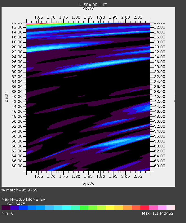
| Estimated Moho Depth: |
10.0 km |
| Estimated Crust Vp/Vs: |
1.65 |
| Assumed Crust Vp: |
6.183 km/s |
| Estimated Crust Vs: |
3.753 km/s |
| Estimated Crust Poisson's Ratio: |
0.21 |
|
| Radial Match: |
95.9759 % |
| Radial Bump: |
379 |
| Transverse Match: |
85.58119 % |
| Transverse Bump: |
356 |
| SOD ConfigId: |
626651 |
| Insert Time: |
2014-04-19 10:32:38.647 +0000 |
| GWidth: |
2.5 |
| Max Bumps: |
400 |
| Tol: |
0.001 |
|
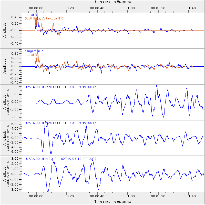
Signal To Noise
| Channel | StoN | STA | LTA |
| IU:SBA:00:HHZ:20131102T19:03:19.491003Z | 9.181001 | 2.2515474E-6 | 2.4523985E-7 |
| IU:SBA:00:HHN:20131102T19:03:19.491003Z | 3.3756883 | 5.537509E-7 | 1.6404088E-7 |
| IU:SBA:00:HHE:20131102T19:03:19.491003Z | 1.9173433 | 3.8318944E-7 | 1.9985438E-7 |
| Arrivals |
| Ps | 1.1 SECOND |
| PpPs | 4.1 SECOND |
| PsPs/PpSs | 5.2 SECOND |


