You are here: Home > Network List > X614 - Homestake Gold Mine Three dimensional Broadband Array Stations List
> Station B4850 4850 level Homestake mine - near shaft 6 > Earthquake Result Viewer
B4850 4850 level Homestake mine - near shaft 6 - Earthquake Result Viewer
| Earthquake location: |
South Of Panama |
| Earthquake latitude/longitude: |
8.0/-82.7 |
| Earthquake time(UTC): |
2014/12/08 (342) 08:54:52 GMT |
| Earthquake Depth: |
20 km |
| Earthquake Magnitude: |
6.6 MWW, 6.3 MWB, 6.7 MI |
| Earthquake Catalog/Contributor: |
NEIC PDE/NEIC COMCAT |
|
| Network: |
X6 Homestake Gold Mine Three dimensional Broadband Array |
| Station: |
B4850 4850 level Homestake mine - near shaft 6 |
| Lat/Lon: |
44.35 N/103.76 W |
| Elevation: |
115 m |
|
| Distance: |
40.6 deg |
| Az: |
336.664 deg |
| Baz: |
146.849 deg |
| Ray Param: |
0.074271865 |
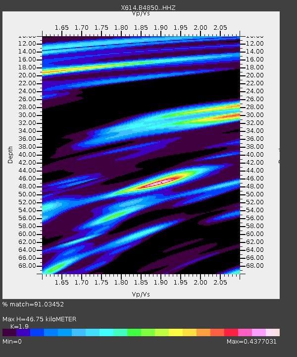
| Estimated Moho Depth: |
46.75 km |
| Estimated Crust Vp/Vs: |
1.90 |
| Assumed Crust Vp: |
6.242 km/s |
| Estimated Crust Vs: |
3.285 km/s |
| Estimated Crust Poisson's Ratio: |
0.31 |
|
| Radial Match: |
91.03452 % |
| Radial Bump: |
245 |
| Transverse Match: |
73.602875 % |
| Transverse Bump: |
400 |
| SOD ConfigId: |
3390531 |
| Insert Time: |
2019-04-15 10:42:15.451 +0000 |
| GWidth: |
2.5 |
| Max Bumps: |
400 |
| Tol: |
0.001 |
|

Signal To Noise
| Channel | StoN | STA | LTA |
| X6:B4850: :HHZ:20141208T09:02:00.399001Z | 9.11489 | 1.9365273E-6 | 2.1245755E-7 |
| X6:B4850: :HHN:20141208T09:02:00.399001Z | 7.200309 | 7.686596E-7 | 1.067537E-7 |
| X6:B4850: :HHE:20141208T09:02:00.399001Z | 7.903209 | 8.6760934E-7 | 1.0977937E-7 |
| Arrivals |
| Ps | 7.2 SECOND |
| PpPs | 20 SECOND |
| PsPs/PpSs | 28 SECOND |


