You are here: Home > Network List > II - Global Seismograph Network (GSN - IRIS/IDA) Stations List
> Station TLY Talaya, Russia > Earthquake Result Viewer
TLY Talaya, Russia - Earthquake Result Viewer

| Earthquake location: |
Solomon Islands |
| Earthquake latitude/longitude: |
-6.8/155.5 |
| Earthquake time(UTC): |
2006/09/01 (244) 10:18:51 GMT |
| Earthquake Depth: |
38 km |
| Earthquake Magnitude: |
6.3 MB, 6.7 MS, 6.8 MW, 6.7 MW |
| Earthquake Catalog/Contributor: |
WHDF/NEIC |
|
| Network: |
II Global Seismograph Network (GSN - IRIS/IDA) |
| Station: |
TLY Talaya, Russia |
| Lat/Lon: |
51.68 N/103.64 E |
| Elevation: |
579 m |
|
| Distance: |
73.1 deg |
| Az: |
329.218 deg |
| Baz: |
125.278 deg |
| Ray Param: |
0.053150464 |
| Estimated Moho Depth: |
11.75 km |
| Estimated Crust Vp/Vs: |
2.09 |
| Assumed Crust Vp: |
6.419 km/s |
| Estimated Crust Vs: |
3.068 km/s |
| Estimated Crust Poisson's Ratio: |
0.35 |
|
| Radial Match: |
97.645294 % |
| Radial Bump: |
242 |
| Transverse Match: |
89.958206 % |
| Transverse Bump: |
400 |
| SOD ConfigId: |
2665 |
| Insert Time: |
2010-03-01 17:43:24.162 +0000 |
| GWidth: |
2.5 |
| Max Bumps: |
400 |
| Tol: |
0.001 |
|
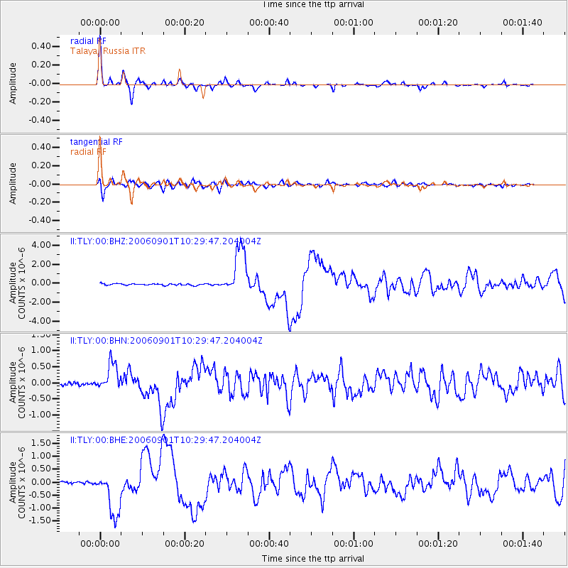
Signal To Noise
| Channel | StoN | STA | LTA |
| II:TLY:00:BHN:20060901T10:29:47.204004Z | 13.2524395 | 4.433924E-7 | 3.3457418E-8 |
| II:TLY:00:BHE:20060901T10:29:47.204004Z | 19.935741 | 8.887846E-7 | 4.458247E-8 |
| II:TLY:00:BHZ:20060901T10:29:47.204004Z | 31.752316 | 2.5730335E-6 | 8.1034514E-8 |
| Arrivals |
| Ps | 2.1 SECOND |
| PpPs | 5.5 SECOND |
| PsPs/PpSs | 7.6 SECOND |


