You are here: Home > Network List > S - Seismographs in Schools Projects Stations List
> Station AULHS Lilydale High School, Lilydale, TAS > Earthquake Result Viewer
AULHS Lilydale High School, Lilydale, TAS - Earthquake Result Viewer
| Earthquake location: |
Tonga Islands Region |
| Earthquake latitude/longitude: |
-19.2/-172.6 |
| Earthquake time(UTC): |
2013/11/02 (306) 18:53:46 GMT |
| Earthquake Depth: |
10 km |
| Earthquake Magnitude: |
6.2 MWW, 6.2 MWB, 6.2 MWW, 6.3 MWC, 6.5 MI |
| Earthquake Catalog/Contributor: |
NEIC PDE/NEIC COMCAT |
|
| Network: |
S Seismographs in Schools Projects |
| Station: |
AULHS Lilydale High School, Lilydale, TAS |
| Lat/Lon: |
41.25 S/147.21 E |
| Elevation: |
173 m |
|
| Distance: |
40.6 deg |
| Az: |
228.325 deg |
| Baz: |
69.447 deg |
| Ray Param: |
0.07430449 |
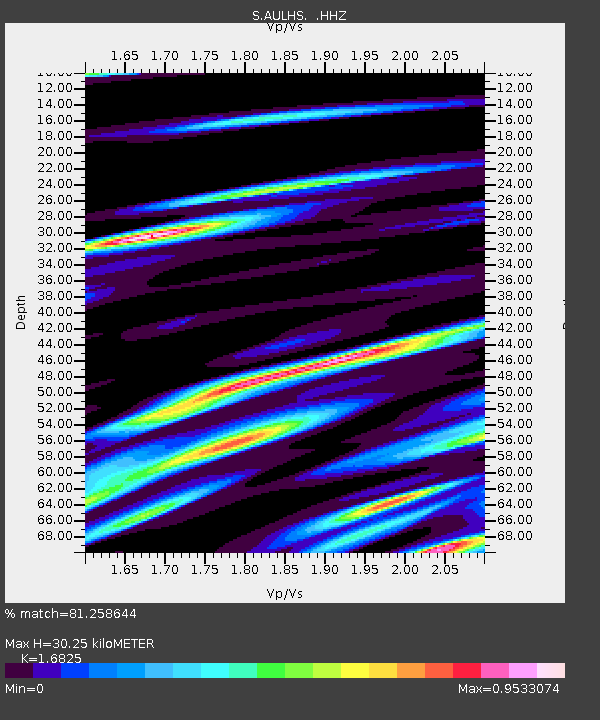
| Estimated Moho Depth: |
30.25 km |
| Estimated Crust Vp/Vs: |
1.68 |
| Assumed Crust Vp: |
6.39 km/s |
| Estimated Crust Vs: |
3.798 km/s |
| Estimated Crust Poisson's Ratio: |
0.23 |
|
| Radial Match: |
81.258644 % |
| Radial Bump: |
393 |
| Transverse Match: |
71.38373 % |
| Transverse Bump: |
400 |
| SOD ConfigId: |
626651 |
| Insert Time: |
2014-04-19 10:36:57.236 +0000 |
| GWidth: |
2.5 |
| Max Bumps: |
400 |
| Tol: |
0.001 |
|

Signal To Noise
| Channel | StoN | STA | LTA |
| S:AULHS: :HHZ:20131102T19:00:55.829993Z | 2.5736995 | 3.0961114E-6 | 1.2029809E-6 |
| S:AULHS: :HHN:20131102T19:00:55.829993Z | 1.4640014 | 1.2164004E-6 | 8.308738E-7 |
| S:AULHS: :HHE:20131102T19:00:55.829993Z | 1.9726741 | 2.1817727E-6 | 1.1059976E-6 |
| Arrivals |
| Ps | 3.5 SECOND |
| PpPs | 12 SECOND |
| PsPs/PpSs | 15 SECOND |


