You are here: Home > Network List > XD14 - Illuminating the architecture of the greater Mount St. Helens magmatic systems f Stations List
> Station MG07 "Mount St Helens, WA" > Earthquake Result Viewer
MG07 "Mount St Helens, WA" - Earthquake Result Viewer
| Earthquake location: |
South Of Panama |
| Earthquake latitude/longitude: |
8.0/-82.7 |
| Earthquake time(UTC): |
2014/12/08 (342) 08:54:52 GMT |
| Earthquake Depth: |
20 km |
| Earthquake Magnitude: |
6.6 MWW, 6.3 MWB, 6.7 MI |
| Earthquake Catalog/Contributor: |
NEIC PDE/NEIC COMCAT |
|
| Network: |
XD Illuminating the architecture of the greater Mount St. Helens magmatic systems f |
| Station: |
MG07 "Mount St Helens, WA" |
| Lat/Lon: |
46.35 N/122.03 W |
| Elevation: |
1457 m |
|
| Distance: |
51.0 deg |
| Az: |
325.575 deg |
| Baz: |
126.06 deg |
| Ray Param: |
0.06769241 |
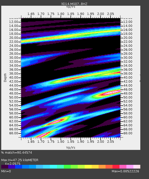
| Estimated Moho Depth: |
47.25 km |
| Estimated Crust Vp/Vs: |
2.06 |
| Assumed Crust Vp: |
6.566 km/s |
| Estimated Crust Vs: |
3.191 km/s |
| Estimated Crust Poisson's Ratio: |
0.35 |
|
| Radial Match: |
90.44574 % |
| Radial Bump: |
400 |
| Transverse Match: |
68.89455 % |
| Transverse Bump: |
400 |
| SOD ConfigId: |
3390531 |
| Insert Time: |
2019-04-15 10:42:43.593 +0000 |
| GWidth: |
2.5 |
| Max Bumps: |
400 |
| Tol: |
0.001 |
|

Signal To Noise
| Channel | StoN | STA | LTA |
| XD:MG07: :BHZ:20141208T09:03:21.875015Z | 5.368878 | 1.3151043E-6 | 2.4494958E-7 |
| XD:MG07: :BHN:20141208T09:03:21.875015Z | 1.8804274 | 3.629061E-7 | 1.9299128E-7 |
| XD:MG07: :BHE:20141208T09:03:21.875015Z | 2.04887 | 5.793739E-7 | 2.8277728E-7 |
| Arrivals |
| Ps | 8.0 SECOND |
| PpPs | 21 SECOND |
| PsPs/PpSs | 29 SECOND |


