You are here: Home > Network List > S - Seismographs in Schools Projects Stations List
> Station AUTAR Taroona High School, Taroona, TAS > Earthquake Result Viewer
AUTAR Taroona High School, Taroona, TAS - Earthquake Result Viewer
| Earthquake location: |
Tonga Islands Region |
| Earthquake latitude/longitude: |
-19.2/-172.6 |
| Earthquake time(UTC): |
2013/11/02 (306) 18:53:46 GMT |
| Earthquake Depth: |
10 km |
| Earthquake Magnitude: |
6.2 MWW, 6.2 MWB, 6.2 MWW, 6.3 MWC, 6.5 MI |
| Earthquake Catalog/Contributor: |
NEIC PDE/NEIC COMCAT |
|
| Network: |
S Seismographs in Schools Projects |
| Station: |
AUTAR Taroona High School, Taroona, TAS |
| Lat/Lon: |
42.94 S/147.36 E |
| Elevation: |
25 m |
|
| Distance: |
41.1 deg |
| Az: |
225.864 deg |
| Baz: |
67.492 deg |
| Ray Param: |
0.073986925 |
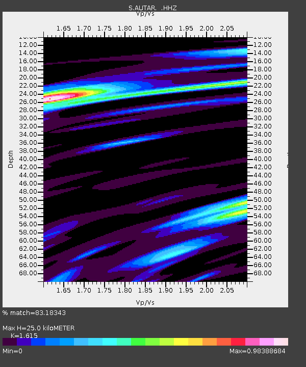
| Estimated Moho Depth: |
25.0 km |
| Estimated Crust Vp/Vs: |
1.62 |
| Assumed Crust Vp: |
6.477 km/s |
| Estimated Crust Vs: |
4.01 km/s |
| Estimated Crust Poisson's Ratio: |
0.19 |
|
| Radial Match: |
83.18343 % |
| Radial Bump: |
400 |
| Transverse Match: |
74.14099 % |
| Transverse Bump: |
400 |
| SOD ConfigId: |
626651 |
| Insert Time: |
2014-04-19 10:37:31.054 +0000 |
| GWidth: |
2.5 |
| Max Bumps: |
400 |
| Tol: |
0.001 |
|

Signal To Noise
| Channel | StoN | STA | LTA |
| S:AUTAR: :HHZ:20131102T19:01:00.13999Z | 3.1865585 | 5.6615722E-6 | 1.7767043E-6 |
| S:AUTAR: :HHN:20131102T19:01:00.13999Z | 2.5289085 | 4.2251595E-6 | 1.6707443E-6 |
| S:AUTAR: :HHE:20131102T19:01:00.13999Z | 1.2437422 | 3.1465001E-6 | 2.5298652E-6 |
| Arrivals |
| Ps | 2.6 SECOND |
| PpPs | 9.3 SECOND |
| PsPs/PpSs | 12 SECOND |


