You are here: Home > Network List > S - Seismographs in Schools Projects Stations List
> Station AUWSH Wavell State High School, QLD > Earthquake Result Viewer
AUWSH Wavell State High School, QLD - Earthquake Result Viewer
| Earthquake location: |
Tonga Islands Region |
| Earthquake latitude/longitude: |
-19.2/-172.6 |
| Earthquake time(UTC): |
2013/11/02 (306) 18:53:46 GMT |
| Earthquake Depth: |
10 km |
| Earthquake Magnitude: |
6.2 MWW, 6.2 MWB, 6.2 MWW, 6.3 MWC, 6.5 MI |
| Earthquake Catalog/Contributor: |
NEIC PDE/NEIC COMCAT |
|
| Network: |
S Seismographs in Schools Projects |
| Station: |
AUWSH Wavell State High School, QLD |
| Lat/Lon: |
27.40 S/153.04 E |
| Elevation: |
60 m |
|
| Distance: |
32.5 deg |
| Az: |
248.947 deg |
| Baz: |
82.824 deg |
| Ray Param: |
0.07862918 |
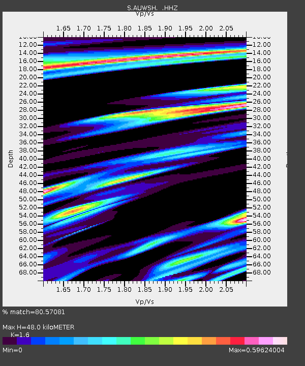
| Estimated Moho Depth: |
48.0 km |
| Estimated Crust Vp/Vs: |
1.60 |
| Assumed Crust Vp: |
6.472 km/s |
| Estimated Crust Vs: |
4.045 km/s |
| Estimated Crust Poisson's Ratio: |
0.18 |
|
| Radial Match: |
80.57081 % |
| Radial Bump: |
306 |
| Transverse Match: |
67.216064 % |
| Transverse Bump: |
400 |
| SOD ConfigId: |
626651 |
| Insert Time: |
2014-04-19 10:37:37.142 +0000 |
| GWidth: |
2.5 |
| Max Bumps: |
400 |
| Tol: |
0.001 |
|

Signal To Noise
| Channel | StoN | STA | LTA |
| S:AUWSH: :HHZ:20131102T18:59:46.810004Z | 9.63985 | 4.8169004E-6 | 4.996863E-7 |
| S:AUWSH: :HHN:20131102T18:59:46.810004Z | 2.1146007 | 1.4343047E-6 | 6.7828637E-7 |
| S:AUWSH: :HHE:20131102T18:59:46.810004Z | 7.2678747 | 3.1786597E-6 | 4.373575E-7 |
| Arrivals |
| Ps | 4.9 SECOND |
| PpPs | 18 SECOND |
| PsPs/PpSs | 23 SECOND |


