You are here: Home > Network List > TA - USArray Transportable Network (new EarthScope stations) Stations List
> Station TUL1 Leonard, OK, USA > Earthquake Result Viewer
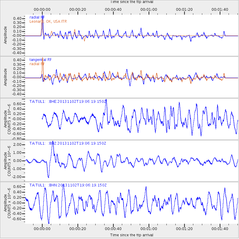
TUL1 Leonard, OK, USA - Earthquake Result Viewer
*The percent match for this event was below the threshold and hence no stack was calculated.
| Earthquake location: |
Tonga Islands Region |
| Earthquake latitude/longitude: |
-19.2/-172.6 |
| Earthquake time(UTC): |
2013/11/02 (306) 18:53:46 GMT |
| Earthquake Depth: |
10 km |
| Earthquake Magnitude: |
6.2 MWW, 6.2 MWB, 6.2 MWW, 6.3 MWC, 6.5 MI |
| Earthquake Catalog/Contributor: |
NEIC PDE/NEIC COMCAT |
|
| Network: |
TA USArray Transportable Network (new EarthScope stations) |
| Station: |
TUL1 Leonard, OK, USA |
| Lat/Lon: |
35.91 N/95.79 W |
| Elevation: |
256 m |
|
| Distance: |
90.9 deg |
| Az: |
52.243 deg |
| Baz: |
247.007 deg |
| Ray Param: |
$rayparam |
*The percent match for this event was below the threshold and hence was not used in the summary stack. |
|
| Radial Match: |
78.564384 % |
| Radial Bump: |
400 |
| Transverse Match: |
61.74923 % |
| Transverse Bump: |
400 |
| SOD ConfigId: |
626651 |
| Insert Time: |
2014-04-19 10:40:09.018 +0000 |
| GWidth: |
2.5 |
| Max Bumps: |
400 |
| Tol: |
0.001 |
|
Signal To Noise
| Channel | StoN | STA | LTA |
| TA:TUL1: :BHZ:20131102T19:06:19.150Z | 7.0554757 | 7.9197173E-7 | 1.1224923E-7 |
| TA:TUL1: :BHN:20131102T19:06:19.150Z | 2.732757 | 4.5947047E-7 | 1.681344E-7 |
| TA:TUL1: :BHE:20131102T19:06:19.150Z | 1.6284927 | 2.665476E-7 | 1.636775E-7 |
| Arrivals |
| Ps | |
| PpPs | |
| PsPs/PpSs | |


