You are here: Home > Network List > UW - Pacific Northwest Regional Seismic Network Stations List
> Station STOR Enumclaw, WA, USA > Earthquake Result Viewer
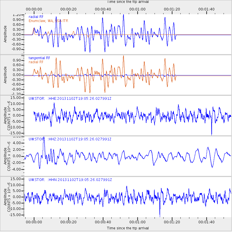
STOR Enumclaw, WA, USA - Earthquake Result Viewer
*The percent match for this event was below the threshold and hence no stack was calculated.
| Earthquake location: |
Tonga Islands Region |
| Earthquake latitude/longitude: |
-19.2/-172.6 |
| Earthquake time(UTC): |
2013/11/02 (306) 18:53:46 GMT |
| Earthquake Depth: |
10 km |
| Earthquake Magnitude: |
6.2 MWW, 6.2 MWB, 6.2 MWW, 6.3 MWC, 6.5 MI |
| Earthquake Catalog/Contributor: |
NEIC PDE/NEIC COMCAT |
|
| Network: |
UW Pacific Northwest Regional Seismic Network |
| Station: |
STOR Enumclaw, WA, USA |
| Lat/Lon: |
47.19 N/121.99 W |
| Elevation: |
266 m |
|
| Distance: |
80.2 deg |
| Az: |
32.359 deg |
| Baz: |
227.881 deg |
| Ray Param: |
$rayparam |
*The percent match for this event was below the threshold and hence was not used in the summary stack. |
|
| Radial Match: |
54.193348 % |
| Radial Bump: |
400 |
| Transverse Match: |
54.144985 % |
| Transverse Bump: |
400 |
| SOD ConfigId: |
626651 |
| Insert Time: |
2014-04-19 10:43:55.598 +0000 |
| GWidth: |
2.5 |
| Max Bumps: |
400 |
| Tol: |
0.001 |
|
Signal To Noise
| Channel | StoN | STA | LTA |
| UW:STOR: :HHZ:20131102T19:05:26.027991Z | 2.8697846 | 1.4966332E-6 | 5.2151415E-7 |
| UW:STOR: :HHN:20131102T19:05:26.027991Z | 0.80313456 | 2.678092E-6 | 3.3345495E-6 |
| UW:STOR: :HHE:20131102T19:05:26.027991Z | 0.80303705 | 2.6791804E-6 | 3.3363099E-6 |
| Arrivals |
| Ps | |
| PpPs | |
| PsPs/PpSs | |


