You are here: Home > Network List > IW - Intermountain West Stations List
> Station IMW Indian Meadow, Wyoming, USA > Earthquake Result Viewer
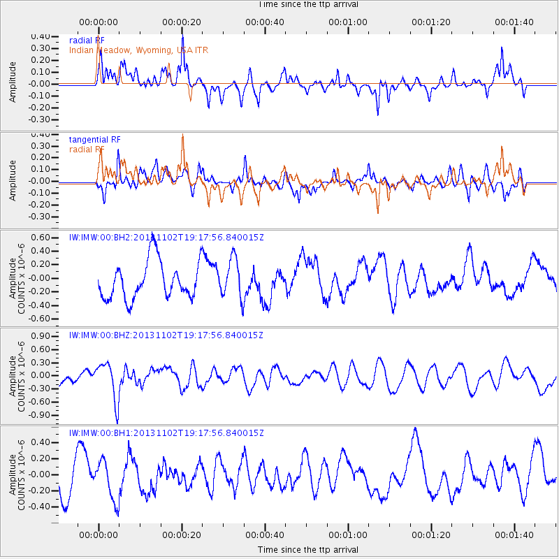
IMW Indian Meadow, Wyoming, USA - Earthquake Result Viewer
*The percent match for this event was below the threshold and hence no stack was calculated.
| Earthquake location: |
Tonga Islands Region |
| Earthquake latitude/longitude: |
-19.2/-172.4 |
| Earthquake time(UTC): |
2013/11/02 (306) 19:05:56 GMT |
| Earthquake Depth: |
10 km |
| Earthquake Magnitude: |
5.7 MWC, 5.7 MWC |
| Earthquake Catalog/Contributor: |
NEIC PDE/NEIC COMCAT |
|
| Network: |
IW Intermountain West |
| Station: |
IMW Indian Meadow, Wyoming, USA |
| Lat/Lon: |
43.90 N/110.94 W |
| Elevation: |
2646 m |
|
| Distance: |
84.2 deg |
| Az: |
39.664 deg |
| Baz: |
236.553 deg |
| Ray Param: |
$rayparam |
*The percent match for this event was below the threshold and hence was not used in the summary stack. |
|
| Radial Match: |
46.99685 % |
| Radial Bump: |
400 |
| Transverse Match: |
46.56144 % |
| Transverse Bump: |
400 |
| SOD ConfigId: |
626651 |
| Insert Time: |
2014-04-19 10:54:32.471 +0000 |
| GWidth: |
2.5 |
| Max Bumps: |
400 |
| Tol: |
0.001 |
|
Signal To Noise
| Channel | StoN | STA | LTA |
| IW:IMW:00:BHZ:20131102T19:17:56.840015Z | 2.2132826 | 4.4559238E-7 | 2.0132647E-7 |
| IW:IMW:00:BH1:20131102T19:17:56.840015Z | 0.8894564 | 2.461017E-7 | 2.7668779E-7 |
| IW:IMW:00:BH2:20131102T19:17:56.840015Z | 1.0765934 | 2.9651218E-7 | 2.7541705E-7 |
| Arrivals |
| Ps | |
| PpPs | |
| PsPs/PpSs | |


