You are here: Home > Network List > TA - USArray Transportable Network (new EarthScope stations) Stations List
> Station L40A Anamosa, IA, USA > Earthquake Result Viewer
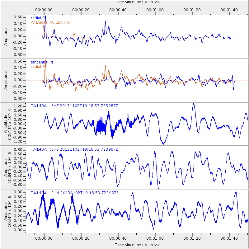
L40A Anamosa, IA, USA - Earthquake Result Viewer
*The percent match for this event was below the threshold and hence no stack was calculated.
| Earthquake location: |
Tonga Islands Region |
| Earthquake latitude/longitude: |
-19.2/-172.4 |
| Earthquake time(UTC): |
2013/11/02 (306) 19:05:56 GMT |
| Earthquake Depth: |
10 km |
| Earthquake Magnitude: |
5.7 MWC, 5.7 MWC |
| Earthquake Catalog/Contributor: |
NEIC PDE/NEIC COMCAT |
|
| Network: |
TA USArray Transportable Network (new EarthScope stations) |
| Station: |
L40A Anamosa, IA, USA |
| Lat/Lon: |
42.06 N/91.22 W |
| Elevation: |
242 m |
|
| Distance: |
96.3 deg |
| Az: |
47.761 deg |
| Baz: |
249.98 deg |
| Ray Param: |
$rayparam |
*The percent match for this event was below the threshold and hence was not used in the summary stack. |
|
| Radial Match: |
61.310196 % |
| Radial Bump: |
400 |
| Transverse Match: |
53.401566 % |
| Transverse Bump: |
400 |
| SOD ConfigId: |
626651 |
| Insert Time: |
2014-04-19 10:58:38.914 +0000 |
| GWidth: |
2.5 |
| Max Bumps: |
400 |
| Tol: |
0.001 |
|
Signal To Noise
| Channel | StoN | STA | LTA |
| TA:L40A: :BHZ:20131102T19:18:53.723987Z | 1.368031 | 3.1511198E-7 | 2.303398E-7 |
| TA:L40A: :BHN:20131102T19:18:53.723987Z | 1.0479997 | 3.7428165E-7 | 3.5713904E-7 |
| TA:L40A: :BHE:20131102T19:18:53.723987Z | 1.3195735 | 3.775723E-7 | 2.8613206E-7 |
| Arrivals |
| Ps | |
| PpPs | |
| PsPs/PpSs | |


