You are here: Home > Network List > US - United States National Seismic Network Stations List
> Station HDIL Hopedale, Illinois, USA > Earthquake Result Viewer
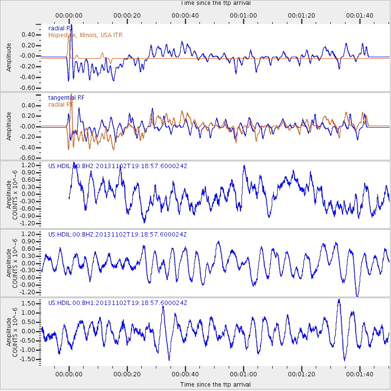
HDIL Hopedale, Illinois, USA - Earthquake Result Viewer
*The percent match for this event was below the threshold and hence no stack was calculated.
| Earthquake location: |
Tonga Islands Region |
| Earthquake latitude/longitude: |
-19.2/-172.4 |
| Earthquake time(UTC): |
2013/11/02 (306) 19:05:56 GMT |
| Earthquake Depth: |
10 km |
| Earthquake Magnitude: |
5.7 MWC, 5.7 MWC |
| Earthquake Catalog/Contributor: |
NEIC PDE/NEIC COMCAT |
|
| Network: |
US United States National Seismic Network |
| Station: |
HDIL Hopedale, Illinois, USA |
| Lat/Lon: |
40.56 N/89.29 W |
| Elevation: |
219 m |
|
| Distance: |
97.2 deg |
| Az: |
49.678 deg |
| Baz: |
251.022 deg |
| Ray Param: |
$rayparam |
*The percent match for this event was below the threshold and hence was not used in the summary stack. |
|
| Radial Match: |
48.249676 % |
| Radial Bump: |
400 |
| Transverse Match: |
45.688343 % |
| Transverse Bump: |
400 |
| SOD ConfigId: |
626651 |
| Insert Time: |
2014-04-19 10:59:42.457 +0000 |
| GWidth: |
2.5 |
| Max Bumps: |
400 |
| Tol: |
0.001 |
|
Signal To Noise
| Channel | StoN | STA | LTA |
| US:HDIL:00:BHZ:20131102T19:18:57.600024Z | 0.9973869 | 2.5993293E-7 | 2.6061397E-7 |
| US:HDIL:00:BH1:20131102T19:18:57.600024Z | 1.2194299 | 5.2315136E-7 | 4.2901308E-7 |
| US:HDIL:00:BH2:20131102T19:18:57.600024Z | 1.1578455 | 5.5142755E-7 | 4.7625312E-7 |
| Arrivals |
| Ps | |
| PpPs | |
| PsPs/PpSs | |


