You are here: Home > Network List > US - United States National Seismic Network Stations List
> Station OGNE Ogallala, Nebraska, USA > Earthquake Result Viewer
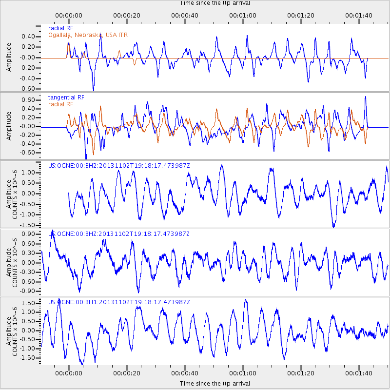
OGNE Ogallala, Nebraska, USA - Earthquake Result Viewer
*The percent match for this event was below the threshold and hence no stack was calculated.
| Earthquake location: |
Tonga Islands Region |
| Earthquake latitude/longitude: |
-19.2/-172.4 |
| Earthquake time(UTC): |
2013/11/02 (306) 19:05:56 GMT |
| Earthquake Depth: |
10 km |
| Earthquake Magnitude: |
5.7 MWC, 5.7 MWC |
| Earthquake Catalog/Contributor: |
NEIC PDE/NEIC COMCAT |
|
| Network: |
US United States National Seismic Network |
| Station: |
OGNE Ogallala, Nebraska, USA |
| Lat/Lon: |
40.95 N/102.03 W |
| Elevation: |
0.0 m |
|
| Distance: |
88.4 deg |
| Az: |
45.539 deg |
| Baz: |
242.923 deg |
| Ray Param: |
$rayparam |
*The percent match for this event was below the threshold and hence was not used in the summary stack. |
|
| Radial Match: |
39.084015 % |
| Radial Bump: |
364 |
| Transverse Match: |
46.984226 % |
| Transverse Bump: |
400 |
| SOD ConfigId: |
626651 |
| Insert Time: |
2014-04-19 10:59:55.798 +0000 |
| GWidth: |
2.5 |
| Max Bumps: |
400 |
| Tol: |
0.001 |
|
Signal To Noise
| Channel | StoN | STA | LTA |
| US:OGNE:00:BHZ:20131102T19:18:17.473987Z | 1.164614 | 4.457508E-7 | 3.8274555E-7 |
| US:OGNE:00:BH1:20131102T19:18:17.473987Z | 1.4176744 | 1.3301681E-6 | 9.3827464E-7 |
| US:OGNE:00:BH2:20131102T19:18:17.473987Z | 0.95219177 | 5.711796E-7 | 5.9985774E-7 |
| Arrivals |
| Ps | |
| PpPs | |
| PsPs/PpSs | |


