You are here: Home > Network List > UW - Pacific Northwest Regional Seismic Network Stations List
> Station UMAT Pilot Rock, OR, USA > Earthquake Result Viewer
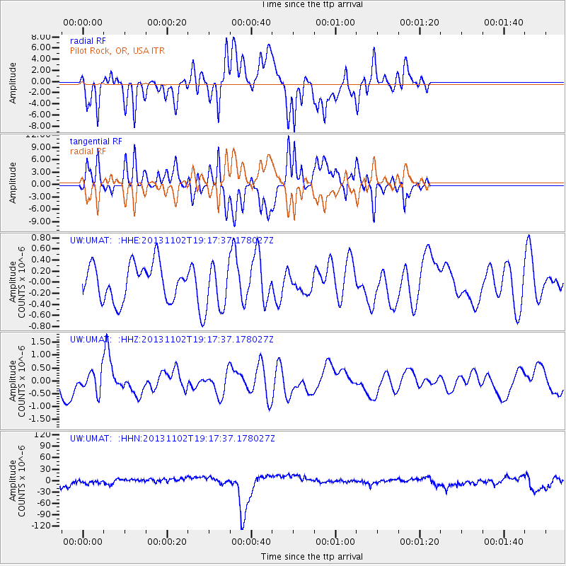
UMAT Pilot Rock, OR, USA - Earthquake Result Viewer
*The percent match for this event was below the threshold and hence no stack was calculated.
| Earthquake location: |
Tonga Islands Region |
| Earthquake latitude/longitude: |
-19.2/-172.4 |
| Earthquake time(UTC): |
2013/11/02 (306) 19:05:56 GMT |
| Earthquake Depth: |
10 km |
| Earthquake Magnitude: |
5.7 MWC, 5.7 MWC |
| Earthquake Catalog/Contributor: |
NEIC PDE/NEIC COMCAT |
|
| Network: |
UW Pacific Northwest Regional Seismic Network |
| Station: |
UMAT Pilot Rock, OR, USA |
| Lat/Lon: |
45.29 N/118.96 W |
| Elevation: |
1318 m |
|
| Distance: |
80.5 deg |
| Az: |
35.096 deg |
| Baz: |
230.327 deg |
| Ray Param: |
$rayparam |
*The percent match for this event was below the threshold and hence was not used in the summary stack. |
|
| Radial Match: |
59.296482 % |
| Radial Bump: |
400 |
| Transverse Match: |
58.898113 % |
| Transverse Bump: |
400 |
| SOD ConfigId: |
626651 |
| Insert Time: |
2014-04-19 11:00:56.240 +0000 |
| GWidth: |
2.5 |
| Max Bumps: |
400 |
| Tol: |
0.001 |
|
Signal To Noise
| Channel | StoN | STA | LTA |
| UW:UMAT: :HHZ:20131102T19:17:37.178027Z | 0.9995283 | 4.0664668E-7 | 4.0683858E-7 |
| UW:UMAT: :HHN:20131102T19:17:37.178027Z | 0.5924496 | 4.8765105E-6 | 8.231097E-6 |
| UW:UMAT: :HHE:20131102T19:17:37.178027Z | 1.2714162 | 4.0765184E-7 | 3.2062815E-7 |
| Arrivals |
| Ps | |
| PpPs | |
| PsPs/PpSs | |


