You are here: Home > Network List > UW - Pacific Northwest Regional Seismic Network Stations List
> Station YACT Amboy, WA, USA > Earthquake Result Viewer
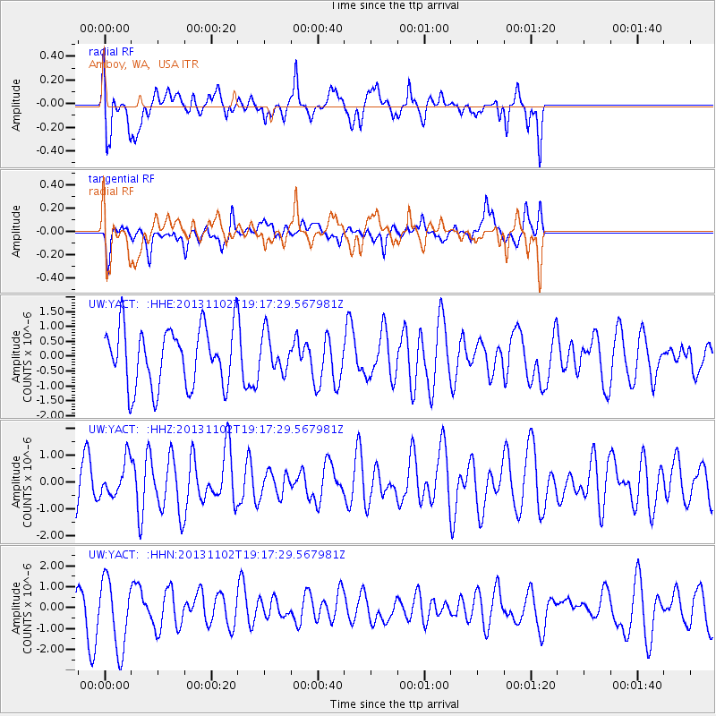
YACT Amboy, WA, USA - Earthquake Result Viewer
*The percent match for this event was below the threshold and hence no stack was calculated.
| Earthquake location: |
Tonga Islands Region |
| Earthquake latitude/longitude: |
-19.2/-172.4 |
| Earthquake time(UTC): |
2013/11/02 (306) 19:05:56 GMT |
| Earthquake Depth: |
10 km |
| Earthquake Magnitude: |
5.7 MWC, 5.7 MWC |
| Earthquake Catalog/Contributor: |
NEIC PDE/NEIC COMCAT |
|
| Network: |
UW Pacific Northwest Regional Seismic Network |
| Station: |
YACT Amboy, WA, USA |
| Lat/Lon: |
45.93 N/122.42 W |
| Elevation: |
211 m |
|
| Distance: |
79.1 deg |
| Az: |
32.982 deg |
| Baz: |
227.487 deg |
| Ray Param: |
$rayparam |
*The percent match for this event was below the threshold and hence was not used in the summary stack. |
|
| Radial Match: |
56.31643 % |
| Radial Bump: |
400 |
| Transverse Match: |
52.674156 % |
| Transverse Bump: |
400 |
| SOD ConfigId: |
626651 |
| Insert Time: |
2014-04-19 11:00:58.079 +0000 |
| GWidth: |
2.5 |
| Max Bumps: |
400 |
| Tol: |
0.001 |
|
Signal To Noise
| Channel | StoN | STA | LTA |
| UW:YACT: :HHZ:20131102T19:17:29.567981Z | 0.89072126 | 6.4153295E-7 | 7.202399E-7 |
| UW:YACT: :HHN:20131102T19:17:29.567981Z | 2.370049 | 1.6713104E-6 | 7.051797E-7 |
| UW:YACT: :HHE:20131102T19:17:29.567981Z | 0.6378447 | 6.2551715E-7 | 9.806731E-7 |
| Arrivals |
| Ps | |
| PpPs | |
| PsPs/PpSs | |


