You are here: Home > Network List > II - Global Seismograph Network (GSN - IRIS/IDA) Stations List
> Station WRAB Tennant Creek, NT, Australia > Earthquake Result Viewer
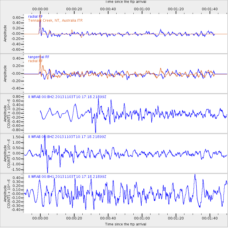
WRAB Tennant Creek, NT, Australia - Earthquake Result Viewer
*The percent match for this event was below the threshold and hence no stack was calculated.
| Earthquake location: |
Tonga Islands Region |
| Earthquake latitude/longitude: |
-19.2/-172.5 |
| Earthquake time(UTC): |
2013/11/03 (307) 10:08:54 GMT |
| Earthquake Depth: |
4.0 km |
| Earthquake Magnitude: |
5.6 MWB, 5.5 MWC |
| Earthquake Catalog/Contributor: |
NEIC PDE/NEIC COMCAT |
|
| Network: |
II Global Seismograph Network (GSN - IRIS/IDA) |
| Station: |
WRAB Tennant Creek, NT, Australia |
| Lat/Lon: |
19.93 S/134.36 E |
| Elevation: |
366 m |
|
| Distance: |
49.9 deg |
| Az: |
259.791 deg |
| Baz: |
98.689 deg |
| Ray Param: |
$rayparam |
*The percent match for this event was below the threshold and hence was not used in the summary stack. |
|
| Radial Match: |
62.38721 % |
| Radial Bump: |
400 |
| Transverse Match: |
66.49972 % |
| Transverse Bump: |
400 |
| SOD ConfigId: |
626651 |
| Insert Time: |
2014-04-19 11:24:04.252 +0000 |
| GWidth: |
2.5 |
| Max Bumps: |
400 |
| Tol: |
0.001 |
|
Signal To Noise
| Channel | StoN | STA | LTA |
| II:WRAB:00:BHZ:20131103T10:17:18.21899Z | 4.500901 | 7.0639135E-7 | 1.5694444E-7 |
| II:WRAB:00:BH1:20131103T10:17:18.21899Z | 2.0883899 | 2.0650225E-7 | 9.888108E-8 |
| II:WRAB:00:BH2:20131103T10:17:18.21899Z | 1.9616125 | 3.4899085E-7 | 1.779102E-7 |
| Arrivals |
| Ps | |
| PpPs | |
| PsPs/PpSs | |


