You are here: Home > Network List > TA - USArray Transportable Network (new EarthScope stations) Stations List
> Station O03E Paynes Creek, CA, USA > Earthquake Result Viewer
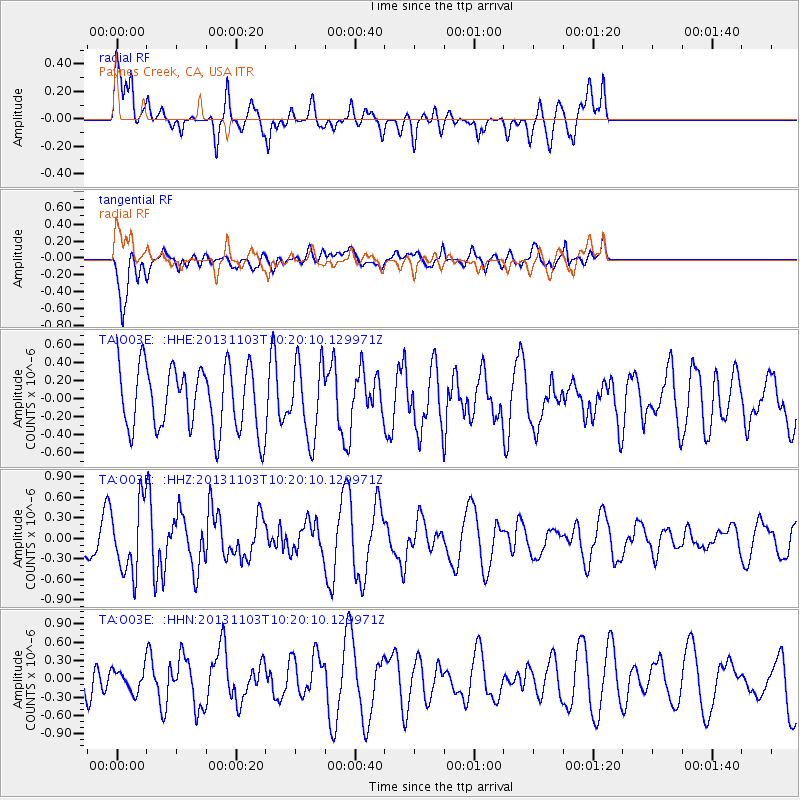
O03E Paynes Creek, CA, USA - Earthquake Result Viewer
*The percent match for this event was below the threshold and hence no stack was calculated.
| Earthquake location: |
Tonga Islands Region |
| Earthquake latitude/longitude: |
-19.2/-172.5 |
| Earthquake time(UTC): |
2013/11/03 (307) 10:08:54 GMT |
| Earthquake Depth: |
4.0 km |
| Earthquake Magnitude: |
5.6 MWB, 5.5 MWC |
| Earthquake Catalog/Contributor: |
NEIC PDE/NEIC COMCAT |
|
| Network: |
TA USArray Transportable Network (new EarthScope stations) |
| Station: |
O03E Paynes Creek, CA, USA |
| Lat/Lon: |
40.29 N/121.80 W |
| Elevation: |
967 m |
|
| Distance: |
75.7 deg |
| Az: |
37.665 deg |
| Baz: |
229.02 deg |
| Ray Param: |
$rayparam |
*The percent match for this event was below the threshold and hence was not used in the summary stack. |
|
| Radial Match: |
54.921623 % |
| Radial Bump: |
400 |
| Transverse Match: |
67.23374 % |
| Transverse Bump: |
400 |
| SOD ConfigId: |
626651 |
| Insert Time: |
2014-04-19 11:29:56.486 +0000 |
| GWidth: |
2.5 |
| Max Bumps: |
400 |
| Tol: |
0.001 |
|
Signal To Noise
| Channel | StoN | STA | LTA |
| TA:O03E: :HHZ:20131103T10:20:10.129971Z | 4.9478993 | 5.0549716E-7 | 1.02163995E-7 |
| TA:O03E: :HHN:20131103T10:20:10.129971Z | 1.0611378 | 1.8074411E-7 | 1.7033047E-7 |
| TA:O03E: :HHE:20131103T10:20:10.129971Z | 1.1632692 | 4.106022E-7 | 3.5297268E-7 |
| Arrivals |
| Ps | |
| PpPs | |
| PsPs/PpSs | |


