You are here: Home > Network List > TA - USArray Transportable Network (new EarthScope stations) Stations List
> Station G59A Clarenceville, QC, USA > Earthquake Result Viewer
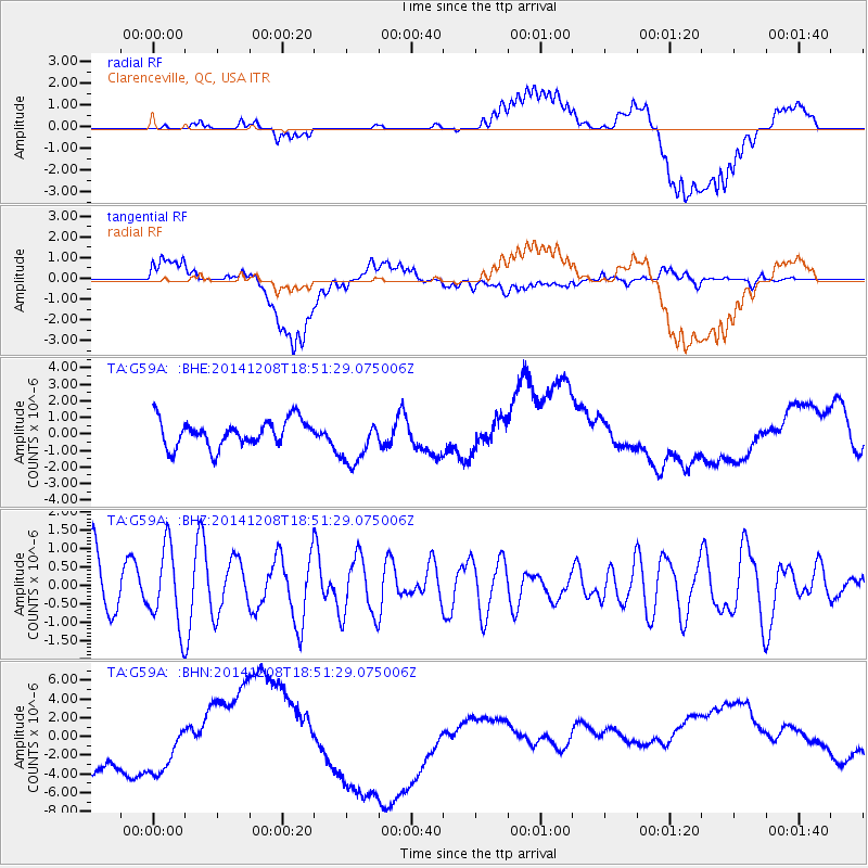
G59A Clarenceville, QC, USA - Earthquake Result Viewer
*The percent match for this event was below the threshold and hence no stack was calculated.
| Earthquake location: |
Panama-Costa Rica Border Region |
| Earthquake latitude/longitude: |
8.0/-82.7 |
| Earthquake time(UTC): |
2014/12/08 (342) 18:44:47 GMT |
| Earthquake Depth: |
42 km |
| Earthquake Magnitude: |
5.4 MW, 5.1 mb, 5.3 Mwb, 5.5 ML |
| Earthquake Catalog/Contributor: |
ISC/ISC |
|
| Network: |
TA USArray Transportable Network (new EarthScope stations) |
| Station: |
G59A Clarenceville, QC, USA |
| Lat/Lon: |
45.08 N/73.18 W |
| Elevation: |
36 m |
|
| Distance: |
37.8 deg |
| Az: |
10.982 deg |
| Baz: |
195.443 deg |
| Ray Param: |
$rayparam |
*The percent match for this event was below the threshold and hence was not used in the summary stack. |
|
| Radial Match: |
32.480125 % |
| Radial Bump: |
400 |
| Transverse Match: |
20.439466 % |
| Transverse Bump: |
400 |
| SOD ConfigId: |
3390531 |
| Insert Time: |
2019-04-15 11:08:31.709 +0000 |
| GWidth: |
2.5 |
| Max Bumps: |
400 |
| Tol: |
0.001 |
|
Signal To Noise
| Channel | StoN | STA | LTA |
| TA:G59A: :BHZ:20141208T18:51:29.075006Z | 1.3191234 | 1.0837787E-6 | 8.2159005E-7 |
| TA:G59A: :BHN:20141208T18:51:29.075006Z | 0.9670996 | 6.5209492E-6 | 6.7427895E-6 |
| TA:G59A: :BHE:20141208T18:51:29.075006Z | 1.768244 | 1.4393403E-6 | 8.139942E-7 |
| Arrivals |
| Ps | |
| PpPs | |
| PsPs/PpSs | |


