You are here: Home > Network List > TA - USArray Transportable Network (new EarthScope stations) Stations List
> Station R11A Troy Canyon, Currant, NV, USA > Earthquake Result Viewer
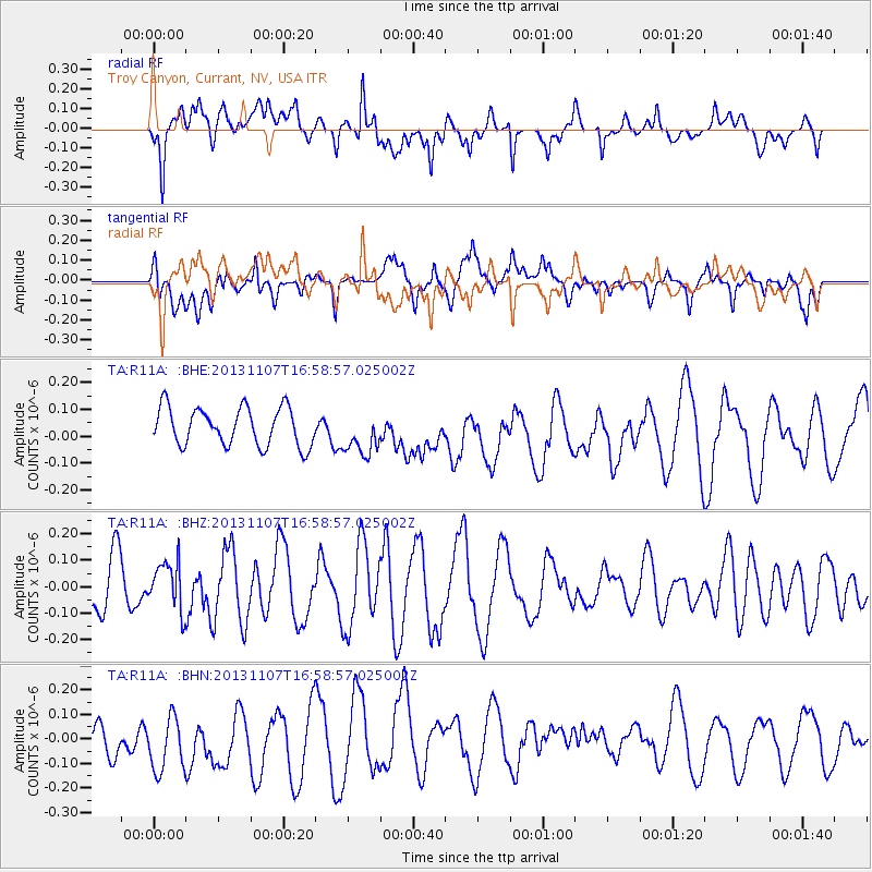
R11A Troy Canyon, Currant, NV, USA - Earthquake Result Viewer
*The percent match for this event was below the threshold and hence no stack was calculated.
| Earthquake location: |
Southeast Of Loyalty Islands |
| Earthquake latitude/longitude: |
-22.3/171.5 |
| Earthquake time(UTC): |
2013/11/07 (311) 16:46:34 GMT |
| Earthquake Depth: |
98 km |
| Earthquake Magnitude: |
5.7 MWW, 5.7 MWB, 5.8 MWC |
| Earthquake Catalog/Contributor: |
NEIC PDE/NEIC COMCAT |
|
| Network: |
TA USArray Transportable Network (new EarthScope stations) |
| Station: |
R11A Troy Canyon, Currant, NV, USA |
| Lat/Lon: |
38.35 N/115.59 W |
| Elevation: |
1756 m |
|
| Distance: |
91.1 deg |
| Az: |
48.723 deg |
| Baz: |
242.255 deg |
| Ray Param: |
$rayparam |
*The percent match for this event was below the threshold and hence was not used in the summary stack. |
|
| Radial Match: |
58.157585 % |
| Radial Bump: |
400 |
| Transverse Match: |
44.941826 % |
| Transverse Bump: |
400 |
| SOD ConfigId: |
626651 |
| Insert Time: |
2014-04-19 12:00:49.163 +0000 |
| GWidth: |
2.5 |
| Max Bumps: |
400 |
| Tol: |
0.001 |
|
Signal To Noise
| Channel | StoN | STA | LTA |
| TA:R11A: :BHZ:20131107T16:58:57.025002Z | 0.55029607 | 8.896826E-8 | 1.6167344E-7 |
| TA:R11A: :BHN:20131107T16:58:57.025002Z | 1.2631478 | 1.4241454E-7 | 1.1274574E-7 |
| TA:R11A: :BHE:20131107T16:58:57.025002Z | 1.1589465 | 8.219862E-8 | 7.092529E-8 |
| Arrivals |
| Ps | |
| PpPs | |
| PsPs/PpSs | |


