You are here: Home > Network List > TA - USArray Transportable Network (new EarthScope stations) Stations List
> Station G59A Clarenceville, QC, USA > Earthquake Result Viewer
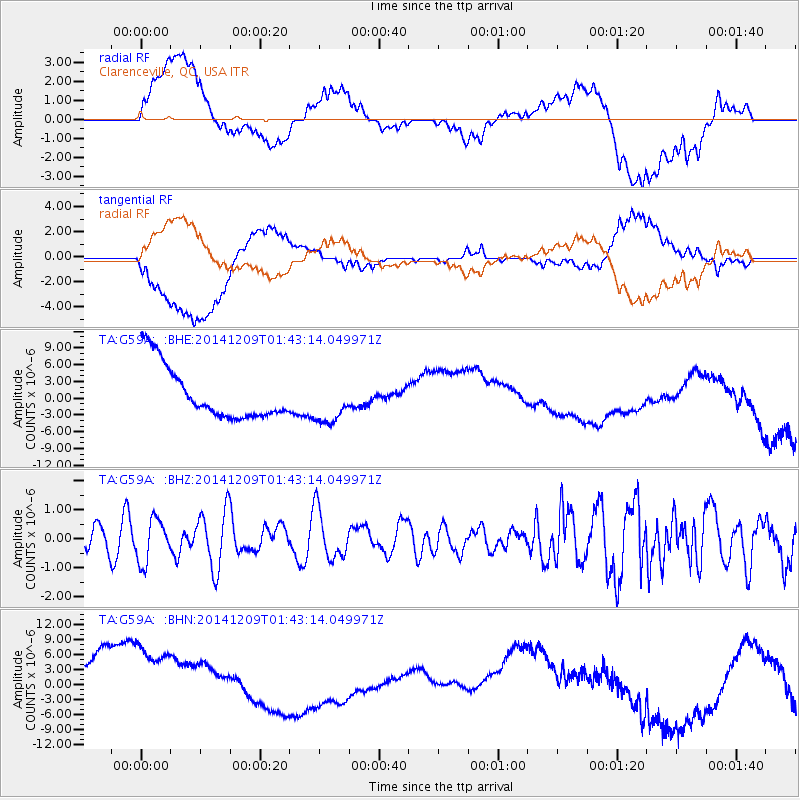
G59A Clarenceville, QC, USA - Earthquake Result Viewer
*The percent match for this event was below the threshold and hence no stack was calculated.
| Earthquake location: |
Southern East Pacific Rise |
| Earthquake latitude/longitude: |
-34.6/-108.9 |
| Earthquake time(UTC): |
2014/12/09 (343) 01:31:07 GMT |
| Earthquake Depth: |
15 km |
| Earthquake Magnitude: |
5.1 MW, 5.1 mb |
| Earthquake Catalog/Contributor: |
ISC/ISC |
|
| Network: |
TA USArray Transportable Network (new EarthScope stations) |
| Station: |
G59A Clarenceville, QC, USA |
| Lat/Lon: |
45.08 N/73.18 W |
| Elevation: |
36 m |
|
| Distance: |
85.6 deg |
| Az: |
24.488 deg |
| Baz: |
208.873 deg |
| Ray Param: |
$rayparam |
*The percent match for this event was below the threshold and hence was not used in the summary stack. |
|
| Radial Match: |
29.855263 % |
| Radial Bump: |
400 |
| Transverse Match: |
32.662636 % |
| Transverse Bump: |
400 |
| SOD ConfigId: |
3390531 |
| Insert Time: |
2019-04-15 11:16:52.534 +0000 |
| GWidth: |
2.5 |
| Max Bumps: |
400 |
| Tol: |
0.001 |
|
Signal To Noise
| Channel | StoN | STA | LTA |
| TA:G59A: :BHZ:20141209T01:43:14.049971Z | 1.2586931 | 7.3732286E-7 | 5.857845E-7 |
| TA:G59A: :BHN:20141209T01:43:14.049971Z | 1.1428542 | 1.6978664E-5 | 1.4856369E-5 |
| TA:G59A: :BHE:20141209T01:43:14.049971Z | 0.8561558 | 4.082892E-6 | 4.7688654E-6 |
| Arrivals |
| Ps | |
| PpPs | |
| PsPs/PpSs | |


