You are here: Home > Network List > TA - USArray Transportable Network (new EarthScope stations) Stations List
> Station Y12C Blythe, CA, USA > Earthquake Result Viewer
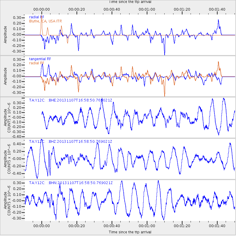
Y12C Blythe, CA, USA - Earthquake Result Viewer
*The percent match for this event was below the threshold and hence no stack was calculated.
| Earthquake location: |
Southeast Of Loyalty Islands |
| Earthquake latitude/longitude: |
-22.3/171.5 |
| Earthquake time(UTC): |
2013/11/07 (311) 16:46:34 GMT |
| Earthquake Depth: |
98 km |
| Earthquake Magnitude: |
5.7 MWW, 5.7 MWB, 5.8 MWC |
| Earthquake Catalog/Contributor: |
NEIC PDE/NEIC COMCAT |
|
| Network: |
TA USArray Transportable Network (new EarthScope stations) |
| Station: |
Y12C Blythe, CA, USA |
| Lat/Lon: |
33.75 N/114.52 W |
| Elevation: |
196 m |
|
| Distance: |
89.7 deg |
| Az: |
53.192 deg |
| Baz: |
242.845 deg |
| Ray Param: |
$rayparam |
*The percent match for this event was below the threshold and hence was not used in the summary stack. |
|
| Radial Match: |
81.69104 % |
| Radial Bump: |
400 |
| Transverse Match: |
55.281696 % |
| Transverse Bump: |
400 |
| SOD ConfigId: |
626651 |
| Insert Time: |
2014-04-19 12:00:56.604 +0000 |
| GWidth: |
2.5 |
| Max Bumps: |
400 |
| Tol: |
0.001 |
|
Signal To Noise
| Channel | StoN | STA | LTA |
| TA:Y12C: :BHZ:20131107T16:58:50.769021Z | 1.8278352 | 3.273223E-7 | 1.7907648E-7 |
| TA:Y12C: :BHN:20131107T16:58:50.769021Z | 0.80600005 | 9.34456E-8 | 1.1593745E-7 |
| TA:Y12C: :BHE:20131107T16:58:50.769021Z | 2.180583 | 2.0317115E-7 | 9.317286E-8 |
| Arrivals |
| Ps | |
| PpPs | |
| PsPs/PpSs | |


