You are here: Home > Network List > TA - USArray Transportable Network (new EarthScope stations) Stations List
> Station H17A Grant Village (NPS), Yellowstone Nt. Park, WY, USA > Earthquake Result Viewer
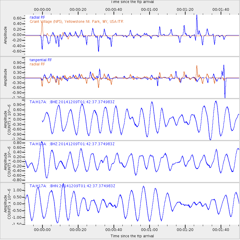
H17A Grant Village (NPS), Yellowstone Nt. Park, WY, USA - Earthquake Result Viewer
*The percent match for this event was below the threshold and hence no stack was calculated.
| Earthquake location: |
Southern East Pacific Rise |
| Earthquake latitude/longitude: |
-34.6/-108.9 |
| Earthquake time(UTC): |
2014/12/09 (343) 01:31:07 GMT |
| Earthquake Depth: |
15 km |
| Earthquake Magnitude: |
5.1 MW, 5.1 mb |
| Earthquake Catalog/Contributor: |
ISC/ISC |
|
| Network: |
TA USArray Transportable Network (new EarthScope stations) |
| Station: |
H17A Grant Village (NPS), Yellowstone Nt. Park, WY, USA |
| Lat/Lon: |
44.40 N/110.58 W |
| Elevation: |
2400 m |
|
| Distance: |
78.6 deg |
| Az: |
358.75 deg |
| Baz: |
178.561 deg |
| Ray Param: |
$rayparam |
*The percent match for this event was below the threshold and hence was not used in the summary stack. |
|
| Radial Match: |
57.837353 % |
| Radial Bump: |
267 |
| Transverse Match: |
49.657993 % |
| Transverse Bump: |
377 |
| SOD ConfigId: |
3390531 |
| Insert Time: |
2019-04-15 11:16:53.500 +0000 |
| GWidth: |
2.5 |
| Max Bumps: |
400 |
| Tol: |
0.001 |
|
Signal To Noise
| Channel | StoN | STA | LTA |
| TA:H17A: :BHZ:20141209T01:42:37.374983Z | 2.8154795 | 5.570541E-7 | 1.9785408E-7 |
| TA:H17A: :BHN:20141209T01:42:37.374983Z | 1.5931538 | 6.996916E-7 | 4.391865E-7 |
| TA:H17A: :BHE:20141209T01:42:37.374983Z | 0.9513453 | 5.071385E-7 | 5.3307514E-7 |
| Arrivals |
| Ps | |
| PpPs | |
| PsPs/PpSs | |


