You are here: Home > Network List > TA - USArray Transportable Network (new EarthScope stations) Stations List
> Station J62A Henniker, NH, USA > Earthquake Result Viewer
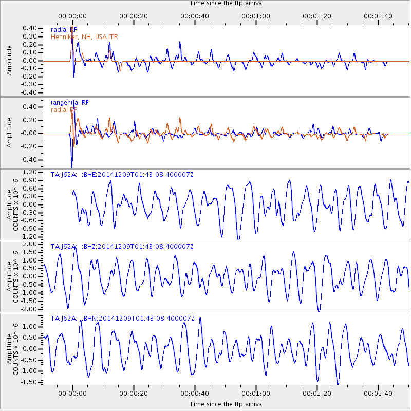
J62A Henniker, NH, USA - Earthquake Result Viewer
*The percent match for this event was below the threshold and hence no stack was calculated.
| Earthquake location: |
Southern East Pacific Rise |
| Earthquake latitude/longitude: |
-34.6/-108.9 |
| Earthquake time(UTC): |
2014/12/09 (343) 01:31:07 GMT |
| Earthquake Depth: |
15 km |
| Earthquake Magnitude: |
5.1 MW, 5.1 mb |
| Earthquake Catalog/Contributor: |
ISC/ISC |
|
| Network: |
TA USArray Transportable Network (new EarthScope stations) |
| Station: |
J62A Henniker, NH, USA |
| Lat/Lon: |
43.23 N/71.81 W |
| Elevation: |
266 m |
|
| Distance: |
84.5 deg |
| Az: |
26.263 deg |
| Baz: |
209.976 deg |
| Ray Param: |
$rayparam |
*The percent match for this event was below the threshold and hence was not used in the summary stack. |
|
| Radial Match: |
65.43612 % |
| Radial Bump: |
400 |
| Transverse Match: |
70.52499 % |
| Transverse Bump: |
400 |
| SOD ConfigId: |
3390531 |
| Insert Time: |
2019-04-15 11:17:00.211 +0000 |
| GWidth: |
2.5 |
| Max Bumps: |
400 |
| Tol: |
0.001 |
|
Signal To Noise
| Channel | StoN | STA | LTA |
| TA:J62A: :BHZ:20141209T01:43:08.400007Z | 1.6059415 | 1.1546875E-6 | 7.190097E-7 |
| TA:J62A: :BHN:20141209T01:43:08.400007Z | 1.4224207 | 6.574487E-7 | 4.622041E-7 |
| TA:J62A: :BHE:20141209T01:43:08.400007Z | 0.99119145 | 4.0946045E-7 | 4.1309923E-7 |
| Arrivals |
| Ps | |
| PpPs | |
| PsPs/PpSs | |


