You are here: Home > Network List > IU - Global Seismograph Network (GSN - IRIS/USGS) Stations List
> Station PMG Port Moresby, New Guinea > Earthquake Result Viewer
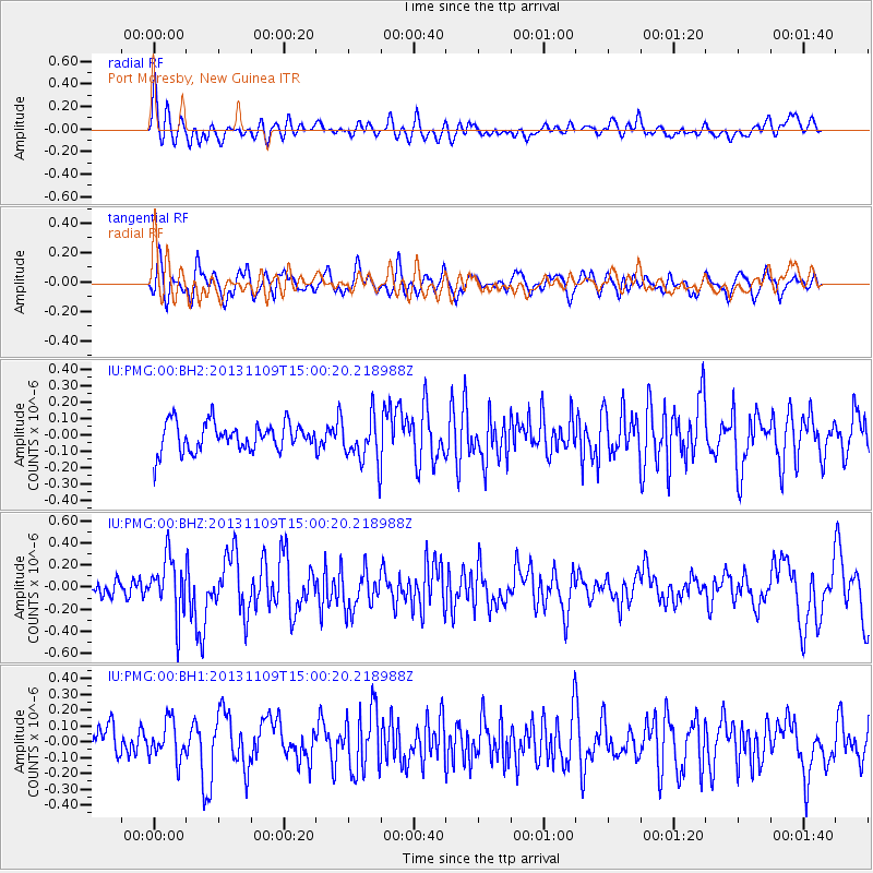
PMG Port Moresby, New Guinea - Earthquake Result Viewer
*The percent match for this event was below the threshold and hence no stack was calculated.
| Earthquake location: |
Kermadec Islands Region |
| Earthquake latitude/longitude: |
-28.3/-176.8 |
| Earthquake time(UTC): |
2013/11/09 (313) 14:53:26 GMT |
| Earthquake Depth: |
10 km |
| Earthquake Magnitude: |
5.5 MWB, 5.5 MWC |
| Earthquake Catalog/Contributor: |
NEIC PDE/NEIC COMCAT |
|
| Network: |
IU Global Seismograph Network (GSN - IRIS/USGS) |
| Station: |
PMG Port Moresby, New Guinea |
| Lat/Lon: |
9.40 S/147.16 E |
| Elevation: |
90 m |
|
| Distance: |
38.8 deg |
| Az: |
291.876 deg |
| Baz: |
123.986 deg |
| Ray Param: |
$rayparam |
*The percent match for this event was below the threshold and hence was not used in the summary stack. |
|
| Radial Match: |
60.914528 % |
| Radial Bump: |
400 |
| Transverse Match: |
61.356606 % |
| Transverse Bump: |
400 |
| SOD ConfigId: |
626651 |
| Insert Time: |
2014-04-19 12:35:25.330 +0000 |
| GWidth: |
2.5 |
| Max Bumps: |
400 |
| Tol: |
0.001 |
|
Signal To Noise
| Channel | StoN | STA | LTA |
| IU:PMG:00:BHZ:20131109T15:00:20.218988Z | 2.6863027 | 2.6285952E-7 | 9.785178E-8 |
| IU:PMG:00:BH1:20131109T15:00:20.218988Z | 0.94923073 | 1.1992474E-7 | 1.2633888E-7 |
| IU:PMG:00:BH2:20131109T15:00:20.218988Z | 1.6026961 | 1.392012E-7 | 8.68544E-8 |
| Arrivals |
| Ps | |
| PpPs | |
| PsPs/PpSs | |


