You are here: Home > Network List > US - United States National Seismic Network Stations List
> Station EGMT Eagleton, Montana, USA > Earthquake Result Viewer
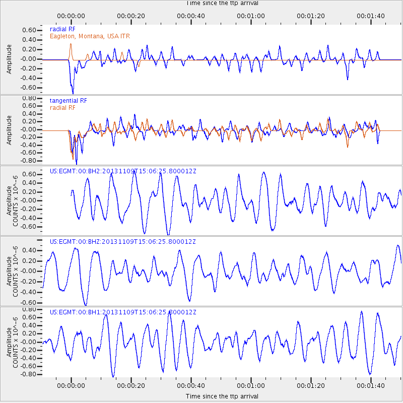
EGMT Eagleton, Montana, USA - Earthquake Result Viewer
*The percent match for this event was below the threshold and hence no stack was calculated.
| Earthquake location: |
Kermadec Islands Region |
| Earthquake latitude/longitude: |
-28.3/-176.8 |
| Earthquake time(UTC): |
2013/11/09 (313) 14:53:26 GMT |
| Earthquake Depth: |
10 km |
| Earthquake Magnitude: |
5.5 MWB, 5.5 MWC |
| Earthquake Catalog/Contributor: |
NEIC PDE/NEIC COMCAT |
|
| Network: |
US United States National Seismic Network |
| Station: |
EGMT Eagleton, Montana, USA |
| Lat/Lon: |
48.02 N/109.75 W |
| Elevation: |
1055 m |
|
| Distance: |
96.8 deg |
| Az: |
38.493 deg |
| Baz: |
234.831 deg |
| Ray Param: |
$rayparam |
*The percent match for this event was below the threshold and hence was not used in the summary stack. |
|
| Radial Match: |
66.900444 % |
| Radial Bump: |
400 |
| Transverse Match: |
58.116447 % |
| Transverse Bump: |
400 |
| SOD ConfigId: |
626651 |
| Insert Time: |
2014-04-19 12:39:31.621 +0000 |
| GWidth: |
2.5 |
| Max Bumps: |
400 |
| Tol: |
0.001 |
|
Signal To Noise
| Channel | StoN | STA | LTA |
| US:EGMT:00:BHZ:20131109T15:06:25.800012Z | 1.5043526 | 3.727586E-7 | 2.4778672E-7 |
| US:EGMT:00:BH1:20131109T15:06:25.800012Z | 0.90986794 | 2.448662E-7 | 2.691228E-7 |
| US:EGMT:00:BH2:20131109T15:06:25.800012Z | 1.3928645 | 4.8674116E-7 | 3.4945333E-7 |
| Arrivals |
| Ps | |
| PpPs | |
| PsPs/PpSs | |


