You are here: Home > Network List > IU - Global Seismograph Network (GSN - IRIS/USGS) Stations List
> Station CTAO Charters Towers, Australia > Earthquake Result Viewer
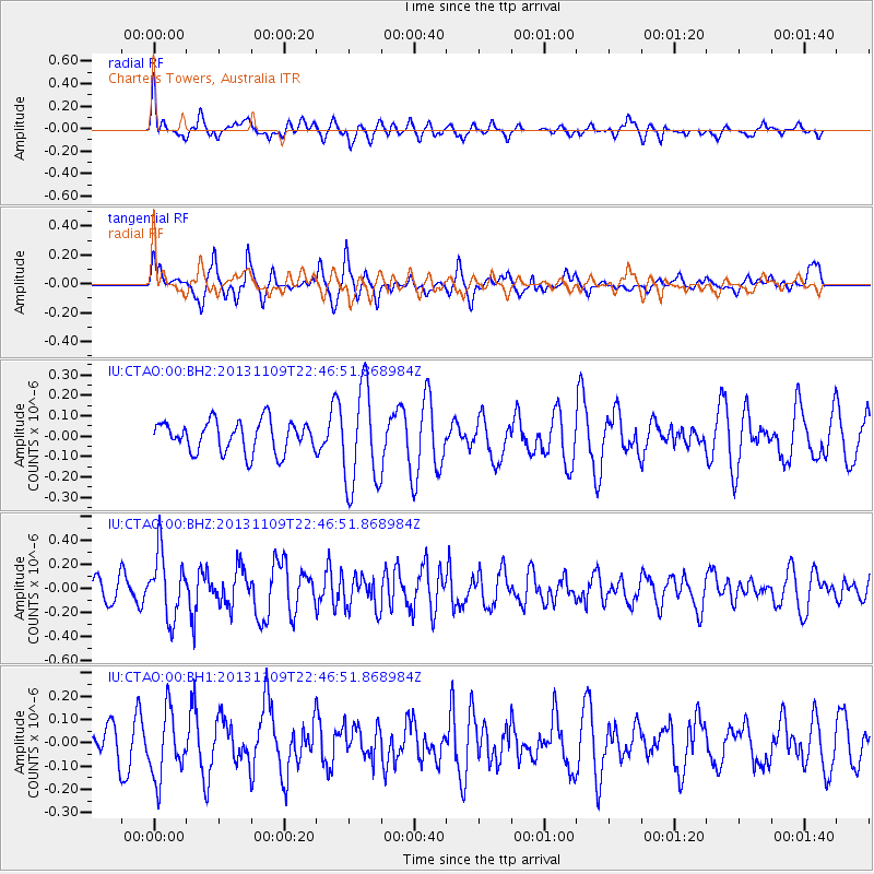
CTAO Charters Towers, Australia - Earthquake Result Viewer
*The percent match for this event was below the threshold and hence no stack was calculated.
| Earthquake location: |
Near S. Coast Of Honshu, Japan |
| Earthquake latitude/longitude: |
35.9/140.0 |
| Earthquake time(UTC): |
2013/11/09 (313) 22:37:50 GMT |
| Earthquake Depth: |
64 km |
| Earthquake Magnitude: |
5.6 MWW, 5.5 MWR, 5.6 MWW, 5.6 MWB, 5.7 MWC |
| Earthquake Catalog/Contributor: |
NEIC PDE/NEIC COMCAT |
|
| Network: |
IU Global Seismograph Network (GSN - IRIS/USGS) |
| Station: |
CTAO Charters Towers, Australia |
| Lat/Lon: |
20.09 S/146.25 E |
| Elevation: |
357 m |
|
| Distance: |
56.0 deg |
| Az: |
172.871 deg |
| Baz: |
353.847 deg |
| Ray Param: |
$rayparam |
*The percent match for this event was below the threshold and hence was not used in the summary stack. |
|
| Radial Match: |
54.177723 % |
| Radial Bump: |
399 |
| Transverse Match: |
65.01792 % |
| Transverse Bump: |
396 |
| SOD ConfigId: |
626651 |
| Insert Time: |
2014-04-19 12:52:15.377 +0000 |
| GWidth: |
2.5 |
| Max Bumps: |
400 |
| Tol: |
0.001 |
|
Signal To Noise
| Channel | StoN | STA | LTA |
| IU:CTAO:00:BHZ:20131109T22:46:51.868984Z | 3.021373 | 2.64437E-7 | 8.752213E-8 |
| IU:CTAO:00:BH1:20131109T22:46:51.868984Z | 1.8569617 | 1.4160916E-7 | 7.625853E-8 |
| IU:CTAO:00:BH2:20131109T22:46:51.868984Z | 3.2337155 | 2.452494E-7 | 7.584136E-8 |
| Arrivals |
| Ps | |
| PpPs | |
| PsPs/PpSs | |


