You are here: Home > Network List > TA - USArray Transportable Network (new EarthScope stations) Stations List
> Station D62A Allapoint, Allagash, ME, USA > Earthquake Result Viewer
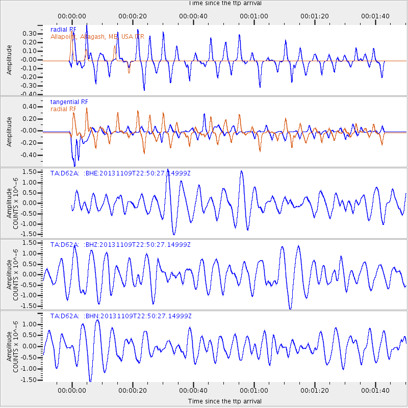
D62A Allapoint, Allagash, ME, USA - Earthquake Result Viewer
*The percent match for this event was below the threshold and hence no stack was calculated.
| Earthquake location: |
Near S. Coast Of Honshu, Japan |
| Earthquake latitude/longitude: |
35.9/140.0 |
| Earthquake time(UTC): |
2013/11/09 (313) 22:37:50 GMT |
| Earthquake Depth: |
64 km |
| Earthquake Magnitude: |
5.6 MWW, 5.5 MWR, 5.6 MWW, 5.6 MWB, 5.7 MWC |
| Earthquake Catalog/Contributor: |
NEIC PDE/NEIC COMCAT |
|
| Network: |
TA USArray Transportable Network (new EarthScope stations) |
| Station: |
D62A Allapoint, Allagash, ME, USA |
| Lat/Lon: |
47.08 N/69.05 W |
| Elevation: |
189 m |
|
| Distance: |
93.4 deg |
| Az: |
19.395 deg |
| Baz: |
336.769 deg |
| Ray Param: |
$rayparam |
*The percent match for this event was below the threshold and hence was not used in the summary stack. |
|
| Radial Match: |
71.43684 % |
| Radial Bump: |
347 |
| Transverse Match: |
67.1068 % |
| Transverse Bump: |
400 |
| SOD ConfigId: |
626651 |
| Insert Time: |
2014-04-19 12:59:42.639 +0000 |
| GWidth: |
2.5 |
| Max Bumps: |
400 |
| Tol: |
0.001 |
|
Signal To Noise
| Channel | StoN | STA | LTA |
| TA:D62A: :BHZ:20131109T22:50:27.14999Z | 1.9961989 | 8.167516E-7 | 4.0915342E-7 |
| TA:D62A: :BHN:20131109T22:50:27.14999Z | 1.5996705 | 5.978217E-7 | 3.7371555E-7 |
| TA:D62A: :BHE:20131109T22:50:27.14999Z | 3.433559 | 9.883244E-7 | 2.8784254E-7 |
| Arrivals |
| Ps | |
| PpPs | |
| PsPs/PpSs | |


