You are here: Home > Network List > TA - USArray Transportable Network (new EarthScope stations) Stations List
> Station R51A Hillsboro, KY, USA > Earthquake Result Viewer
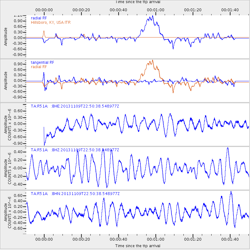
R51A Hillsboro, KY, USA - Earthquake Result Viewer
*The percent match for this event was below the threshold and hence no stack was calculated.
| Earthquake location: |
Near S. Coast Of Honshu, Japan |
| Earthquake latitude/longitude: |
35.9/140.0 |
| Earthquake time(UTC): |
2013/11/09 (313) 22:37:50 GMT |
| Earthquake Depth: |
64 km |
| Earthquake Magnitude: |
5.6 MWW, 5.5 MWR, 5.6 MWW, 5.6 MWB, 5.7 MWC |
| Earthquake Catalog/Contributor: |
NEIC PDE/NEIC COMCAT |
|
| Network: |
TA USArray Transportable Network (new EarthScope stations) |
| Station: |
R51A Hillsboro, KY, USA |
| Lat/Lon: |
38.30 N/83.58 W |
| Elevation: |
231 m |
|
| Distance: |
95.9 deg |
| Az: |
33.023 deg |
| Baz: |
325.79 deg |
| Ray Param: |
$rayparam |
*The percent match for this event was below the threshold and hence was not used in the summary stack. |
|
| Radial Match: |
38.78816 % |
| Radial Bump: |
400 |
| Transverse Match: |
71.51446 % |
| Transverse Bump: |
400 |
| SOD ConfigId: |
626651 |
| Insert Time: |
2014-04-19 13:04:35.268 +0000 |
| GWidth: |
2.5 |
| Max Bumps: |
400 |
| Tol: |
0.001 |
|
Signal To Noise
| Channel | StoN | STA | LTA |
| TA:R51A: :BHZ:20131109T22:50:38.548977Z | 0.49901798 | 9.365651E-8 | 1.8768164E-7 |
| TA:R51A: :BHN:20131109T22:50:38.548977Z | 0.8120108 | 3.4647869E-7 | 4.266922E-7 |
| TA:R51A: :BHE:20131109T22:50:38.548977Z | 0.7752822 | 2.2526842E-7 | 2.9056312E-7 |
| Arrivals |
| Ps | |
| PpPs | |
| PsPs/PpSs | |


