You are here: Home > Network List > US - United States National Seismic Network Stations List
> Station CBKS Cedar Bluff, Kansas, USA > Earthquake Result Viewer
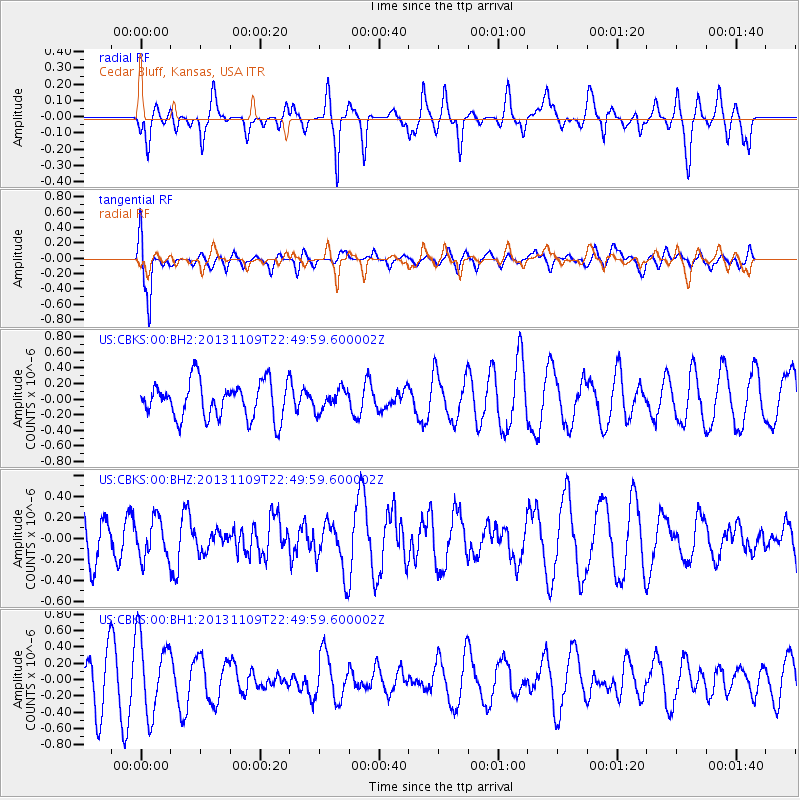
CBKS Cedar Bluff, Kansas, USA - Earthquake Result Viewer
*The percent match for this event was below the threshold and hence no stack was calculated.
| Earthquake location: |
Near S. Coast Of Honshu, Japan |
| Earthquake latitude/longitude: |
35.9/140.0 |
| Earthquake time(UTC): |
2013/11/09 (313) 22:37:50 GMT |
| Earthquake Depth: |
64 km |
| Earthquake Magnitude: |
5.6 MWW, 5.5 MWR, 5.6 MWW, 5.6 MWB, 5.7 MWC |
| Earthquake Catalog/Contributor: |
NEIC PDE/NEIC COMCAT |
|
| Network: |
US United States National Seismic Network |
| Station: |
CBKS Cedar Bluff, Kansas, USA |
| Lat/Lon: |
38.81 N/99.74 W |
| Elevation: |
677 m |
|
| Distance: |
87.4 deg |
| Az: |
42.472 deg |
| Baz: |
315.447 deg |
| Ray Param: |
$rayparam |
*The percent match for this event was below the threshold and hence was not used in the summary stack. |
|
| Radial Match: |
53.448906 % |
| Radial Bump: |
400 |
| Transverse Match: |
76.80895 % |
| Transverse Bump: |
400 |
| SOD ConfigId: |
626651 |
| Insert Time: |
2014-04-19 13:06:02.417 +0000 |
| GWidth: |
2.5 |
| Max Bumps: |
400 |
| Tol: |
0.001 |
|
Signal To Noise
| Channel | StoN | STA | LTA |
| US:CBKS:00:BHZ:20131109T22:49:59.600002Z | 0.75113904 | 1.8810823E-7 | 2.5043065E-7 |
| US:CBKS:00:BH1:20131109T22:49:59.600002Z | 1.4310794 | 4.7675042E-7 | 3.3314043E-7 |
| US:CBKS:00:BH2:20131109T22:49:59.600002Z | 0.5722567 | 1.3396597E-7 | 2.341012E-7 |
| Arrivals |
| Ps | |
| PpPs | |
| PsPs/PpSs | |


