You are here: Home > Network List > IU - Global Seismograph Network (GSN - IRIS/USGS) Stations List
> Station TEIG Tepich, Yucatan, Mexico > Earthquake Result Viewer
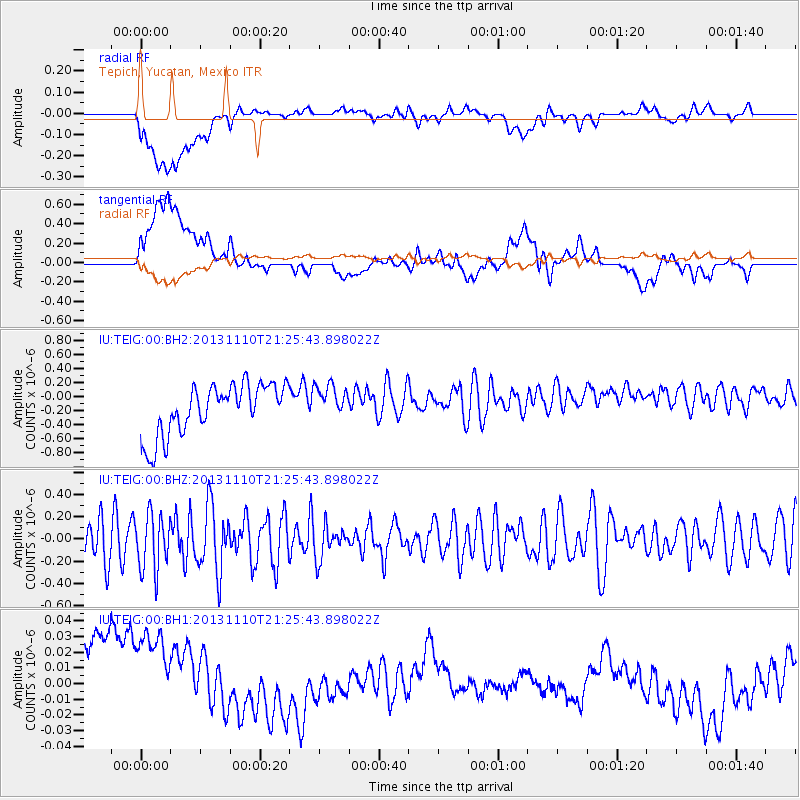
TEIG Tepich, Yucatan, Mexico - Earthquake Result Viewer
*The percent match for this event was below the threshold and hence no stack was calculated.
| Earthquake location: |
Pacific-Antarctic Ridge |
| Earthquake latitude/longitude: |
-54.9/-130.6 |
| Earthquake time(UTC): |
2013/11/10 (314) 21:13:49 GMT |
| Earthquake Depth: |
10 km |
| Earthquake Magnitude: |
5.6 MWB, 5.8 MWC |
| Earthquake Catalog/Contributor: |
NEIC PDE/NEIC COMCAT |
|
| Network: |
IU Global Seismograph Network (GSN - IRIS/USGS) |
| Station: |
TEIG Tepich, Yucatan, Mexico |
| Lat/Lon: |
20.23 N/88.28 W |
| Elevation: |
40 m |
|
| Distance: |
83.1 deg |
| Az: |
39.539 deg |
| Baz: |
203.034 deg |
| Ray Param: |
$rayparam |
*The percent match for this event was below the threshold and hence was not used in the summary stack. |
|
| Radial Match: |
31.419565 % |
| Radial Bump: |
400 |
| Transverse Match: |
26.250137 % |
| Transverse Bump: |
400 |
| SOD ConfigId: |
626651 |
| Insert Time: |
2014-04-19 13:14:56.559 +0000 |
| GWidth: |
2.5 |
| Max Bumps: |
400 |
| Tol: |
0.001 |
|
Signal To Noise
| Channel | StoN | STA | LTA |
| IU:TEIG:00:BHZ:20131110T21:25:43.898022Z | 1.5082624 | 2.5037806E-7 | 1.6600431E-7 |
| IU:TEIG:00:BH1:20131110T21:25:43.898022Z | 1.2946165 | 6.0070754E-8 | 4.6400423E-8 |
| IU:TEIG:00:BH2:20131110T21:25:43.898022Z | 0.702146 | 2.5434053E-7 | 3.622331E-7 |
| Arrivals |
| Ps | |
| PpPs | |
| PsPs/PpSs | |


