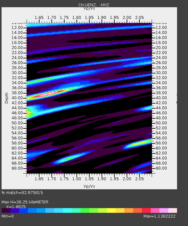
LIENZ Kamor / St. Gall - Earthquake Result Viewer

Earthquake location: Near East Coast Of Kamchatka
Earthquake latitude/longitude: 54.7/162.3
Earthquake time(UTC): 2013/11/12 (316) 07:03:51 GMT
Earthquake Depth: 43 km
Earthquake Magnitude: 6.4 MWW, 6.3 MWC, 6.4 MWW, 6.4 MWB, 6.5 MWC, 6.6 MI
Earthquake Catalog/Contributor: NEIC PDE/NEIC COMCAT
Network: CH Switzerland Seismological Network
Station: LIENZ Kamor / St. Gall
Lat/Lon: 47.29 N/9.49 E
Elevation: 1720 m
Distance: 75.8 deg
Az: 341.288 deg
Baz: 15.882 deg
Ray Param: 0.051333122
Estimated Moho Depth: 38.25 km
Estimated Crust Vp/Vs: 1.68
Assumed Crust Vp: 6.416 km/s
Estimated Crust Vs: 3.813 km/s
Estimated Crust Poisson's Ratio: 0.23
Radial Match: 82.975815 %
Radial Bump: 316
Transverse Match: 73.51584 %
Transverse Bump: 400
SOD ConfigId: 626651
Insert Time: 2014-04-19 13:26:29.064 +0000
GWidth: 2.5
Max Bumps: 400
Tol: 0.001

Signal To Noise

ChannelStoNSTALTA
CH:LIENZ: :HHZ:20131112T07:15:01.75803Z14.7920177.030376E-64.7528178E-7
CH:LIENZ: :HHN:20131112T07:15:01.75803Z6.09688332.8817624E-64.7266155E-7
CH:LIENZ: :HHE:20131112T07:15:01.75803Z3.97715122.7715478E-66.968676E-7
Arrivals
Ps4.2 SECOND
PpPs15 SECOND
PsPs/PpSs20 SECOND