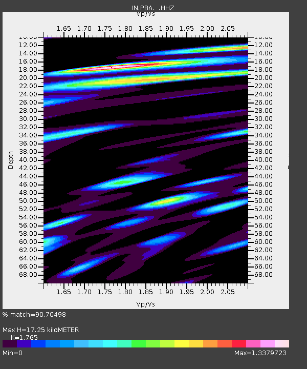
PBA Port Blair, Andaman and Nicobar Islands, India - Earthquake Result Viewer

Earthquake location: Near East Coast Of Kamchatka
Earthquake latitude/longitude: 54.7/162.3
Earthquake time(UTC): 2013/11/12 (316) 07:03:51 GMT
Earthquake Depth: 43 km
Earthquake Magnitude: 6.4 MWW, 6.3 MWC, 6.4 MWW, 6.4 MWB, 6.5 MWC, 6.6 MI
Earthquake Catalog/Contributor: NEIC PDE/NEIC COMCAT
Network: IN National Seismic Network of India
Station: PBA Port Blair, Andaman and Nicobar Islands, India
Lat/Lon: 11.66 N/92.74 E
Elevation: 79 m
Distance: 68.8 deg
Az: 259.991 deg
Baz: 35.71 deg
Ray Param: 0.05600656
Estimated Moho Depth: 17.25 km
Estimated Crust Vp/Vs: 1.76
Assumed Crust Vp: 6.32 km/s
Estimated Crust Vs: 3.581 km/s
Estimated Crust Poisson's Ratio: 0.26
Radial Match: 90.70498 %
Radial Bump: 400
Transverse Match: 74.03168 %
Transverse Bump: 400
SOD ConfigId: 626651
Insert Time: 2014-04-19 13:35:11.411 +0000
GWidth: 2.5
Max Bumps: 400
Tol: 0.001

Signal To Noise

ChannelStoNSTALTA
IN:PBA: :HHZ:20131112T07:14:19.800022Z26.6136381.5756124E-55.9203194E-7
IN:PBA: :HHN:20131112T07:14:19.800022Z17.7010521.17244135E-56.623569E-7
IN:PBA: :HHE:20131112T07:14:19.800022Z8.78665356.973663E-67.9366544E-7
Arrivals
Ps2.2 SECOND
PpPs7.3 SECOND
PsPs/PpSs9.4 SECOND