You are here: Home > Network List > IU - Global Seismograph Network (GSN - IRIS/USGS) Stations List
> Station POHA Pohakuloa, Hawaii, USA > Earthquake Result Viewer
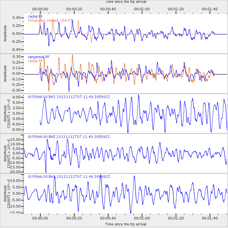
POHA Pohakuloa, Hawaii, USA - Earthquake Result Viewer
*The percent match for this event was below the threshold and hence no stack was calculated.
| Earthquake location: |
Near East Coast Of Kamchatka |
| Earthquake latitude/longitude: |
54.7/162.3 |
| Earthquake time(UTC): |
2013/11/12 (316) 07:03:51 GMT |
| Earthquake Depth: |
43 km |
| Earthquake Magnitude: |
6.4 MWW, 6.3 MWC, 6.4 MWW, 6.4 MWB, 6.5 MWC, 6.6 MI |
| Earthquake Catalog/Contributor: |
NEIC PDE/NEIC COMCAT |
|
| Network: |
IU Global Seismograph Network (GSN - IRIS/USGS) |
| Station: |
POHA Pohakuloa, Hawaii, USA |
| Lat/Lon: |
19.76 N/155.53 W |
| Elevation: |
1990 m |
|
| Distance: |
47.2 deg |
| Az: |
120.557 deg |
| Baz: |
327.935 deg |
| Ray Param: |
$rayparam |
*The percent match for this event was below the threshold and hence was not used in the summary stack. |
|
| Radial Match: |
76.38843 % |
| Radial Bump: |
400 |
| Transverse Match: |
66.55947 % |
| Transverse Bump: |
343 |
| SOD ConfigId: |
626651 |
| Insert Time: |
2014-04-19 13:36:05.258 +0000 |
| GWidth: |
2.5 |
| Max Bumps: |
400 |
| Tol: |
0.001 |
|
Signal To Noise
| Channel | StoN | STA | LTA |
| IU:POHA:00:BHZ:20131112T07:11:49.368992Z | 2.7429383 | 8.292048E-6 | 3.023053E-6 |
| IU:POHA:00:BH1:20131112T07:11:49.368992Z | 1.5409269 | 3.5305727E-6 | 2.2912006E-6 |
| IU:POHA:00:BH2:20131112T07:11:49.368992Z | 0.8686271 | 2.6903037E-6 | 3.0971908E-6 |
| Arrivals |
| Ps | |
| PpPs | |
| PsPs/PpSs | |


