You are here: Home > Network List > PF - Volcanologic Network of Piton de Fournaise-OVPF Stations List
> Station GPS Grandes Pentes Sud > Earthquake Result Viewer
GPS Grandes Pentes Sud - Earthquake Result Viewer
*The percent match for this event was below the threshold and hence no stack was calculated.
| Earthquake location: |
South Sandwich Islands Region |
| Earthquake latitude/longitude: |
-59.0/-25.6 |
| Earthquake time(UTC): |
2014/12/09 (343) 19:23:36 GMT |
| Earthquake Depth: |
51 km |
| Earthquake Magnitude: |
5.1 mb |
| Earthquake Catalog/Contributor: |
ISC/ISC |
|
| Network: |
PF Volcanologic Network of Piton de Fournaise-OVPF |
| Station: |
GPS Grandes Pentes Sud |
| Lat/Lon: |
21.27 S/55.76 E |
| Elevation: |
1004 m |
|
| Distance: |
67.6 deg |
| Az: |
94.145 deg |
| Baz: |
213.613 deg |
| Ray Param: |
$rayparam |
*The percent match for this event was below the threshold and hence was not used in the summary stack. |
|
| Radial Match: |
45.177254 % |
| Radial Bump: |
400 |
| Transverse Match: |
42.833466 % |
| Transverse Bump: |
400 |
| SOD ConfigId: |
3390531 |
| Insert Time: |
2019-04-15 11:44:46.483 +0000 |
| GWidth: |
2.5 |
| Max Bumps: |
400 |
| Tol: |
0.001 |
|
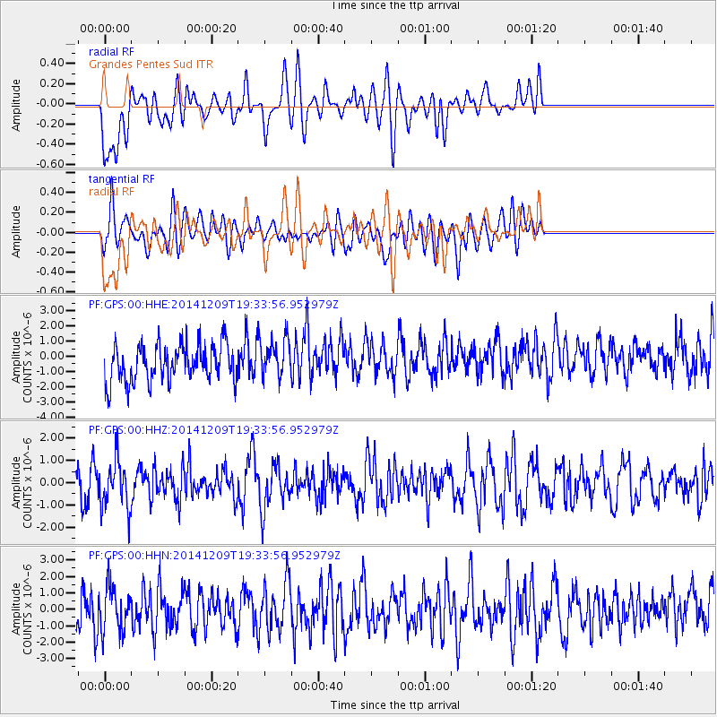
Signal To Noise
| Channel | StoN | STA | LTA |
| PF:GPS:00:HHZ:20141209T19:33:56.952979Z | 1.2656983 | 1.0782746E-6 | 8.519207E-7 |
| PF:GPS:00:HHN:20141209T19:33:56.952979Z | 1.0951408 | 1.3492296E-6 | 1.2320147E-6 |
| PF:GPS:00:HHE:20141209T19:33:56.952979Z | 1.0346736 | 1.2692984E-6 | 1.2267623E-6 |
| Arrivals |
| Ps | |
| PpPs | |
| PsPs/PpSs | |


