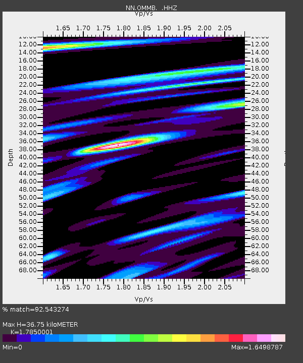
OMMB Old Mammoth Mine, surface, wgs-84 - Earthquake Result Viewer

Earthquake location: Near East Coast Of Kamchatka
Earthquake latitude/longitude: 54.7/162.3
Earthquake time(UTC): 2013/11/12 (316) 07:03:51 GMT
Earthquake Depth: 43 km
Earthquake Magnitude: 6.4 MWW, 6.3 MWC, 6.4 MWW, 6.4 MWB, 6.5 MWC, 6.6 MI
Earthquake Catalog/Contributor: NEIC PDE/NEIC COMCAT
Network: NN Western Great Basin/Eastern Sierra Nevada
Station: OMMB Old Mammoth Mine, surface, wgs-84
Lat/Lon: 37.61 N/119.00 W
Elevation: 2768 m
Distance: 54.2 deg
Az: 73.805 deg
Baz: 315.4 deg
Ray Param: 0.06551495
Estimated Moho Depth: 36.75 km
Estimated Crust Vp/Vs: 1.79
Assumed Crust Vp: 6.291 km/s
Estimated Crust Vs: 3.525 km/s
Estimated Crust Poisson's Ratio: 0.27
Radial Match: 92.543274 %
Radial Bump: 400
Transverse Match: 86.71058 %
Transverse Bump: 400
SOD ConfigId: 626651
Insert Time: 2014-04-19 13:41:35.301 +0000
GWidth: 2.5
Max Bumps: 400
Tol: 0.001

Signal To Noise

ChannelStoNSTALTA
NN:OMMB: :HHZ:20131112T07:12:41.564976Z12.8043992.9798518E-62.3272095E-7
NN:OMMB: :HHN:20131112T07:12:41.564976Z1.93077996.7404056E-73.4910272E-7
NN:OMMB: :HHE:20131112T07:12:41.564976Z9.9447881.5317424E-61.5402465E-7
Arrivals
Ps4.8 SECOND
PpPs15 SECOND
PsPs/PpSs20 SECOND