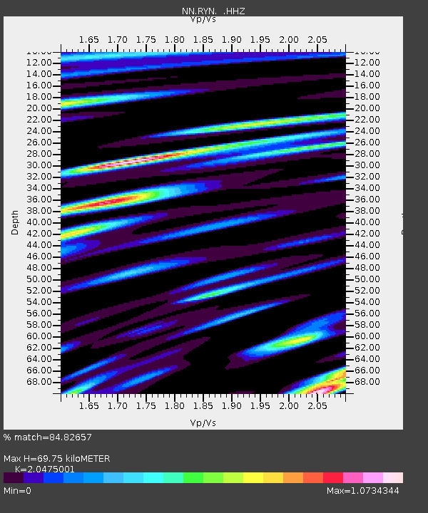
RYN Ryan, Nevada w84,gps - Earthquake Result Viewer

Earthquake location: Near East Coast Of Kamchatka
Earthquake latitude/longitude: 54.7/162.3
Earthquake time(UTC): 2013/11/12 (316) 07:03:51 GMT
Earthquake Depth: 43 km
Earthquake Magnitude: 6.4 MWW, 6.3 MWC, 6.4 MWW, 6.4 MWB, 6.5 MWC, 6.6 MI
Earthquake Catalog/Contributor: NEIC PDE/NEIC COMCAT
Network: NN Western Great Basin/Eastern Sierra Nevada
Station: RYN Ryan, Nevada w84,gps
Lat/Lon: 38.63 N/118.52 W
Elevation: 1651 m
Distance: 53.7 deg
Az: 72.591 deg
Baz: 314.979 deg
Ray Param: 0.065804705
Estimated Moho Depth: 69.75 km
Estimated Crust Vp/Vs: 2.05
Assumed Crust Vp: 6.279 km/s
Estimated Crust Vs: 3.066 km/s
Estimated Crust Poisson's Ratio: 0.34
Radial Match: 84.82657 %
Radial Bump: 382
Transverse Match: 69.322 %
Transverse Bump: 400
SOD ConfigId: 626651
Insert Time: 2014-04-19 13:41:45.834 +0000
GWidth: 2.5
Max Bumps: 400
Tol: 0.001

Signal To Noise

ChannelStoNSTALTA
NN:RYN: :HHZ:20131112T07:12:38.269993Z32.3397034.043715E-61.2503872E-7
NN:RYN: :HHN:20131112T07:12:38.269993Z3.02653748.231356E-72.719727E-7
NN:RYN: :HHE:20131112T07:12:38.269993Z7.6914961.3841105E-61.7995336E-7
Arrivals
Ps12 SECOND
PpPs32 SECOND
PsPs/PpSs45 SECOND