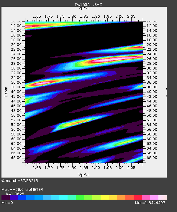
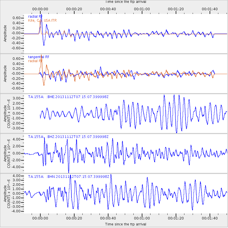
155A Kite, GA, USA - Earthquake Result Viewer

Earthquake location: Near East Coast Of Kamchatka
Earthquake latitude/longitude: 54.7/162.3
Earthquake time(UTC): 2013/11/12 (316) 07:03:51 GMT
Earthquake Depth: 43 km
Earthquake Magnitude: 6.4 MWW, 6.3 MWC, 6.4 MWW, 6.4 MWB, 6.5 MWC, 6.6 MI
Earthquake Catalog/Contributor: NEIC PDE/NEIC COMCAT
Network: TA USArray Transportable Network (new EarthScope stations)
Station: 155A Kite, GA, USA
Lat/Lon: 32.62 N/82.47 W
Elevation: 93 m
Distance: 76.8 deg
Az: 51.63 deg
Baz: 327.354 deg
Ray Param: 0.050662633
Estimated Moho Depth: 26.0 km
Estimated Crust Vp/Vs: 1.96
Assumed Crust Vp: 6.565 km/s
Estimated Crust Vs: 3.345 km/s
Estimated Crust Poisson's Ratio: 0.32
Radial Match: 87.58218 %
Radial Bump: 341
Transverse Match: 85.58249 %
Transverse Bump: 341
SOD ConfigId: 626651
Insert Time: 2014-04-19 13:46:33.269 +0000
GWidth: 2.5
Max Bumps: 400
Tol: 0.001

Signal To Noise

ChannelStoNSTALTA
TA:155A: :BHZ:20131112T07:15:07.399998Z7.47147751.8038018E-62.4142506E-7
TA:155A: :BHN:20131112T07:15:07.399998Z1.28783676.7302904E-75.2260435E-7
TA:155A: :BHE:20131112T07:15:07.399998Z1.04186566.8314904E-76.5569793E-7
Arrivals
Ps3.9 SECOND
PpPs11 SECOND
PsPs/PpSs15 SECOND