355A Pearson, GA, USA - Earthquake Result Viewer
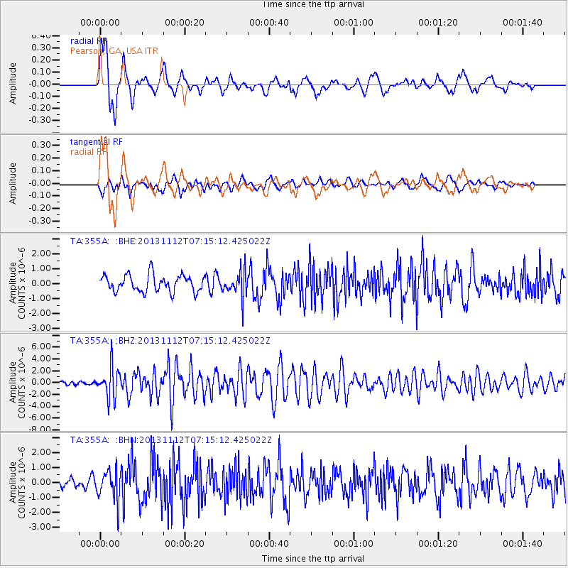
Earthquake location: Near East Coast Of Kamchatka
Earthquake latitude/longitude: 54.7/162.3
Earthquake time(UTC): 2013/11/12 (316) 07:03:51 GMT
Earthquake Depth: 43 km
Earthquake Magnitude: 6.4 MWW, 6.3 MWC, 6.4 MWW, 6.4 MWB, 6.5 MWC, 6.6 MI
Earthquake Catalog/Contributor: NEIC PDE/NEIC COMCAT
Network: TA USArray Transportable Network (new EarthScope stations)
Station: 355A Pearson, GA, USA
Lat/Lon: 31.34 N/82.85 W
Elevation: 69 m
Distance: 77.7 deg
Az: 52.617 deg
Baz: 327.368 deg
Ray Param: 0.050057907
Estimated Moho Depth: 16.25 km
Estimated Crust Vp/Vs: 1.61
Assumed Crust Vp: 6.565 km/s
Estimated Crust Vs: 4.077 km/s
Estimated Crust Poisson's Ratio: 0.19
Radial Match: 82.79081 %
Radial Bump: 400
Transverse Match: 59.21563 %
Transverse Bump: 400
SOD ConfigId: 626651
Insert Time: 2014-04-19 13:47:05.783 +0000
GWidth: 2.5
Max Bumps: 400
Tol: 0.001

Signal To Noise

ChannelStoNSTALTA
TA:355A: :BHZ:20131112T07:15:12.425022Z9.9241692.6174898E-62.6374903E-7
TA:355A: :BHN:20131112T07:15:12.425022Z2.8467461.0224707E-63.5917174E-7
TA:355A: :BHE:20131112T07:15:12.425022Z1.50733218.461156E-75.6133325E-7
Arrivals
Ps1.6 SECOND
PpPs6.2 SECOND
PsPs/PpSs7.8 SECOND