833A Chaparral WMA, Artesia Wells, TX, USA - Earthquake Result Viewer
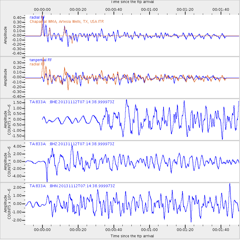
Earthquake location: Near East Coast Of Kamchatka
Earthquake latitude/longitude: 54.7/162.3
Earthquake time(UTC): 2013/11/12 (316) 07:03:51 GMT
Earthquake Depth: 43 km
Earthquake Magnitude: 6.4 MWW, 6.3 MWC, 6.4 MWW, 6.4 MWB, 6.5 MWC, 6.6 MI
Earthquake Catalog/Contributor: NEIC PDE/NEIC COMCAT
Network: TA USArray Transportable Network (new EarthScope stations)
Station: 833A Chaparral WMA, Artesia Wells, TX, USA
Lat/Lon: 28.32 N/99.39 W
Elevation: 171 m
Distance: 71.9 deg
Az: 66.588 deg
Baz: 322.814 deg
Ray Param: 0.053928543
Estimated Moho Depth: 22.75 km
Estimated Crust Vp/Vs: 1.60
Assumed Crust Vp: 6.347 km/s
Estimated Crust Vs: 3.967 km/s
Estimated Crust Poisson's Ratio: 0.18
Radial Match: 83.83438 %
Radial Bump: 400
Transverse Match: 73.59158 %
Transverse Bump: 400
SOD ConfigId: 626651
Insert Time: 2014-04-19 13:47:40.294 +0000
GWidth: 2.5
Max Bumps: 400
Tol: 0.001

Signal To Noise

ChannelStoNSTALTA
TA:833A: :BHZ:20131112T07:14:38.999973Z8.0909721.6480279E-62.0368726E-7
TA:833A: :BHN:20131112T07:14:38.999973Z1.25423124.222422E-73.366542E-7
TA:833A: :BHE:20131112T07:14:38.999973Z2.07148743.9507844E-71.907221E-7
Arrivals
Ps2.2 SECOND
PpPs9.0 SECOND
PsPs/PpSs11 SECOND