BGNE Belgrade, NE, USA - Earthquake Result Viewer
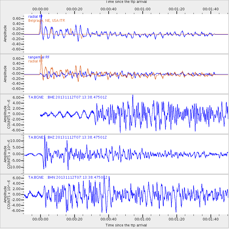
Earthquake location: Near East Coast Of Kamchatka
Earthquake latitude/longitude: 54.7/162.3
Earthquake time(UTC): 2013/11/12 (316) 07:03:51 GMT
Earthquake Depth: 43 km
Earthquake Magnitude: 6.4 MWW, 6.3 MWC, 6.4 MWW, 6.4 MWB, 6.5 MWC, 6.6 MI
Earthquake Catalog/Contributor: NEIC PDE/NEIC COMCAT
Network: TA USArray Transportable Network (new EarthScope stations)
Station: BGNE Belgrade, NE, USA
Lat/Lon: 41.41 N/98.15 W
Elevation: 573 m
Distance: 62.4 deg
Az: 56.867 deg
Baz: 319.729 deg
Ray Param: 0.060194977
Estimated Moho Depth: 61.0 km
Estimated Crust Vp/Vs: 1.63
Assumed Crust Vp: 6.53 km/s
Estimated Crust Vs: 4.0 km/s
Estimated Crust Poisson's Ratio: 0.20
Radial Match: 93.37802 %
Radial Bump: 399
Transverse Match: 75.27819 %
Transverse Bump: 400
SOD ConfigId: 626651
Insert Time: 2014-04-19 13:47:55.535 +0000
GWidth: 2.5
Max Bumps: 400
Tol: 0.001

Signal To Noise

ChannelStoNSTALTA
TA:BGNE: :BHZ:20131112T07:13:38.47501Z15.2776395.4860966E-63.590932E-7
TA:BGNE: :BHN:20131112T07:13:38.47501Z2.59927081.7335232E-66.669267E-7
TA:BGNE: :BHE:20131112T07:13:38.47501Z2.76374131.6394663E-65.932054E-7
Arrivals
Ps6.2 SECOND
PpPs23 SECOND
PsPs/PpSs30 SECOND