C06D Leavenworth, WQ, USA - Earthquake Result Viewer
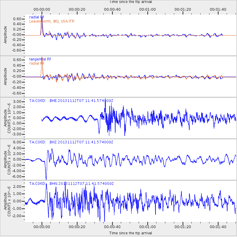
Earthquake location: Near East Coast Of Kamchatka
Earthquake latitude/longitude: 54.7/162.3
Earthquake time(UTC): 2013/11/12 (316) 07:03:51 GMT
Earthquake Depth: 43 km
Earthquake Magnitude: 6.4 MWW, 6.3 MWC, 6.4 MWW, 6.4 MWB, 6.5 MWC, 6.6 MI
Earthquake Catalog/Contributor: NEIC PDE/NEIC COMCAT
Network: TA USArray Transportable Network (new EarthScope stations)
Station: C06D Leavenworth, WQ, USA
Lat/Lon: 47.92 N/120.89 W
Elevation: 544 m
Distance: 46.2 deg
Az: 65.05 deg
Baz: 308.491 deg
Ray Param: 0.07066669
Estimated Moho Depth: 36.5 km
Estimated Crust Vp/Vs: 1.81
Assumed Crust Vp: 6.597 km/s
Estimated Crust Vs: 3.655 km/s
Estimated Crust Poisson's Ratio: 0.28
Radial Match: 83.40619 %
Radial Bump: 400
Transverse Match: 65.00197 %
Transverse Bump: 400
SOD ConfigId: 626651
Insert Time: 2014-04-19 13:47:56.271 +0000
GWidth: 2.5
Max Bumps: 400
Tol: 0.001

Signal To Noise

ChannelStoNSTALTA
TA:C06D: :BHZ:20131112T07:11:41.574009Z11.5054122.490671E-62.1647821E-7
TA:C06D: :BHN:20131112T07:11:41.574009Z3.979729.482272E-72.382648E-7
TA:C06D: :BHE:20131112T07:11:41.574009Z3.82887829.625937E-72.514036E-7
Arrivals
Ps4.8 SECOND
PpPs15 SECOND
PsPs/PpSs19 SECOND