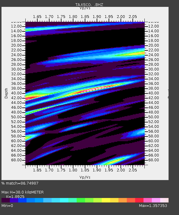
KSCO Kaye Shedlock's, Cheyenne Wells, CO, USA - Earthquake Result Viewer
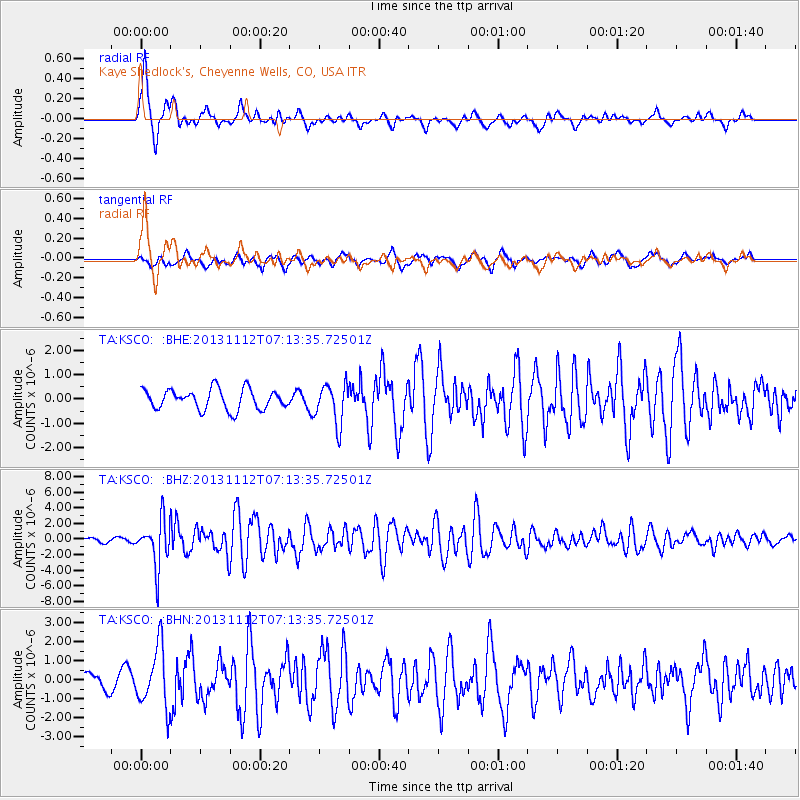
Earthquake location: Near East Coast Of Kamchatka
Earthquake latitude/longitude: 54.7/162.3
Earthquake time(UTC): 2013/11/12 (316) 07:03:51 GMT
Earthquake Depth: 43 km
Earthquake Magnitude: 6.4 MWW, 6.3 MWC, 6.4 MWW, 6.4 MWB, 6.5 MWC, 6.6 MI
Earthquake Catalog/Contributor: NEIC PDE/NEIC COMCAT
Network: TA USArray Transportable Network (new EarthScope stations)
Station: KSCO Kaye Shedlock's, Cheyenne Wells, CO, USA
Lat/Lon: 39.01 N/102.63 W
Elevation: 1382 m
Distance: 61.9 deg
Az: 61.573 deg
Baz: 319.048 deg
Ray Param: 0.06046964
Estimated Moho Depth: 38.0 km
Estimated Crust Vp/Vs: 1.89
Assumed Crust Vp: 6.242 km/s
Estimated Crust Vs: 3.298 km/s
Estimated Crust Poisson's Ratio: 0.31
Radial Match: 86.74987 %
Radial Bump: 393
Transverse Match: 74.82719 %
Transverse Bump: 400
SOD ConfigId: 626651
Insert Time: 2014-04-19 13:52:04.481 +0000
GWidth: 2.5
Max Bumps: 400
Tol: 0.001

Signal To Noise

ChannelStoNSTALTA
TA:KSCO: :BHZ:20131112T07:13:35.72501Z12.58011152.9694966E-62.3604692E-7
TA:KSCO: :BHN:20131112T07:13:35.72501Z2.57275991.5769115E-66.12926E-7
TA:KSCO: :BHE:20131112T07:13:35.72501Z1.9812748.2239853E-74.150857E-7
Arrivals
Ps5.7 SECOND
PpPs17 SECOND
PsPs/PpSs23 SECOND