You are here: Home > Network List > TA - USArray Transportable Network (new EarthScope stations) Stations List
> Station N56A West Decatur, PA, USA > Earthquake Result Viewer
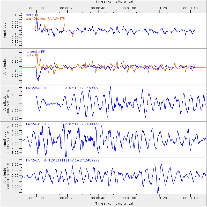
N56A West Decatur, PA, USA - Earthquake Result Viewer
*The percent match for this event was below the threshold and hence no stack was calculated.
| Earthquake location: |
Near East Coast Of Kamchatka |
| Earthquake latitude/longitude: |
54.7/162.3 |
| Earthquake time(UTC): |
2013/11/12 (316) 07:03:51 GMT |
| Earthquake Depth: |
43 km |
| Earthquake Magnitude: |
6.4 MWW, 6.3 MWC, 6.4 MWW, 6.4 MWB, 6.5 MWC, 6.6 MI |
| Earthquake Catalog/Contributor: |
NEIC PDE/NEIC COMCAT |
|
| Network: |
TA USArray Transportable Network (new EarthScope stations) |
| Station: |
N56A West Decatur, PA, USA |
| Lat/Lon: |
40.92 N/78.30 W |
| Elevation: |
561 m |
|
| Distance: |
71.6 deg |
| Az: |
44.081 deg |
| Baz: |
327.79 deg |
| Ray Param: |
$rayparam |
*The percent match for this event was below the threshold and hence was not used in the summary stack. |
|
| Radial Match: |
54.781685 % |
| Radial Bump: |
399 |
| Transverse Match: |
63.08747 % |
| Transverse Bump: |
400 |
| SOD ConfigId: |
626651 |
| Insert Time: |
2014-04-19 13:53:54.828 +0000 |
| GWidth: |
2.5 |
| Max Bumps: |
400 |
| Tol: |
0.001 |
|
Signal To Noise
| Channel | StoN | STA | LTA |
| TA:N56A: :BHZ:20131112T07:14:37.248997Z | 3.015235 | 1.6010963E-6 | 5.310022E-7 |
| TA:N56A: :BHN:20131112T07:14:37.248997Z | 1.6254029 | 6.3054017E-7 | 3.8792854E-7 |
| TA:N56A: :BHE:20131112T07:14:37.248997Z | 2.563717 | 1.2183104E-6 | 4.7521254E-7 |
| Arrivals |
| Ps | |
| PpPs | |
| PsPs/PpSs | |


