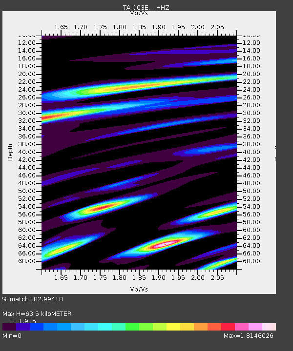
O03E Paynes Creek, CA, USA - Earthquake Result Viewer
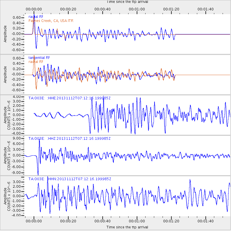
Earthquake location: Near East Coast Of Kamchatka
Earthquake latitude/longitude: 54.7/162.3
Earthquake time(UTC): 2013/11/12 (316) 07:03:51 GMT
Earthquake Depth: 43 km
Earthquake Magnitude: 6.4 MWW, 6.3 MWC, 6.4 MWW, 6.4 MWB, 6.5 MWC, 6.6 MI
Earthquake Catalog/Contributor: NEIC PDE/NEIC COMCAT
Network: TA USArray Transportable Network (new EarthScope stations)
Station: O03E Paynes Creek, CA, USA
Lat/Lon: 40.29 N/121.80 W
Elevation: 967 m
Distance: 50.8 deg
Az: 73.318 deg
Baz: 313.348 deg
Ray Param: 0.06774799
Estimated Moho Depth: 63.5 km
Estimated Crust Vp/Vs: 1.91
Assumed Crust Vp: 6.566 km/s
Estimated Crust Vs: 3.429 km/s
Estimated Crust Poisson's Ratio: 0.31
Radial Match: 82.99418 %
Radial Bump: 400
Transverse Match: 81.268555 %
Transverse Bump: 400
SOD ConfigId: 626651
Insert Time: 2014-04-19 13:54:09.058 +0000
GWidth: 2.5
Max Bumps: 400
Tol: 0.001

Signal To Noise

ChannelStoNSTALTA
TA:O03E: :HHZ:20131112T07:12:16.199985Z14.7085593.8270496E-62.6019202E-7
TA:O03E: :HHN:20131112T07:12:16.199985Z4.24466471.3551327E-63.1925552E-7
TA:O03E: :HHE:20131112T07:12:16.199985Z5.41639231.724509E-63.18387E-7
Arrivals
Ps9.4 SECOND
PpPs27 SECOND
PsPs/PpSs36 SECOND