You are here: Home > Network List > II - Global Seismograph Network (GSN - IRIS/IDA) Stations List
> Station TLY Talaya, Russia > Earthquake Result Viewer
TLY Talaya, Russia - Earthquake Result Viewer
| Earthquake location: |
Iceland |
| Earthquake latitude/longitude: |
64.0/-20.5 |
| Earthquake time(UTC): |
2000/06/17 (169) 15:40:41 GMT |
| Earthquake Depth: |
10 km |
| Earthquake Magnitude: |
5.7 MB, 6.6 MS, 6.8 MW, 6.5 MW |
| Earthquake Catalog/Contributor: |
WHDF/NEIC |
|
| Network: |
II Global Seismograph Network (GSN - IRIS/IDA) |
| Station: |
TLY Talaya, Russia |
| Lat/Lon: |
51.68 N/103.64 E |
| Elevation: |
579 m |
|
| Distance: |
56.8 deg |
| Az: |
38.035 deg |
| Baz: |
334.106 deg |
| Ray Param: |
0.06392737 |
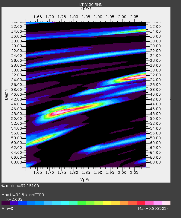
| Estimated Moho Depth: |
32.5 km |
| Estimated Crust Vp/Vs: |
2.07 |
| Assumed Crust Vp: |
6.419 km/s |
| Estimated Crust Vs: |
3.109 km/s |
| Estimated Crust Poisson's Ratio: |
0.35 |
|
| Radial Match: |
97.15193 % |
| Radial Bump: |
324 |
| Transverse Match: |
88.634476 % |
| Transverse Bump: |
400 |
| SOD ConfigId: |
3744 |
| Insert Time: |
2010-03-01 17:51:28.762 +0000 |
| GWidth: |
2.5 |
| Max Bumps: |
400 |
| Tol: |
0.001 |
|
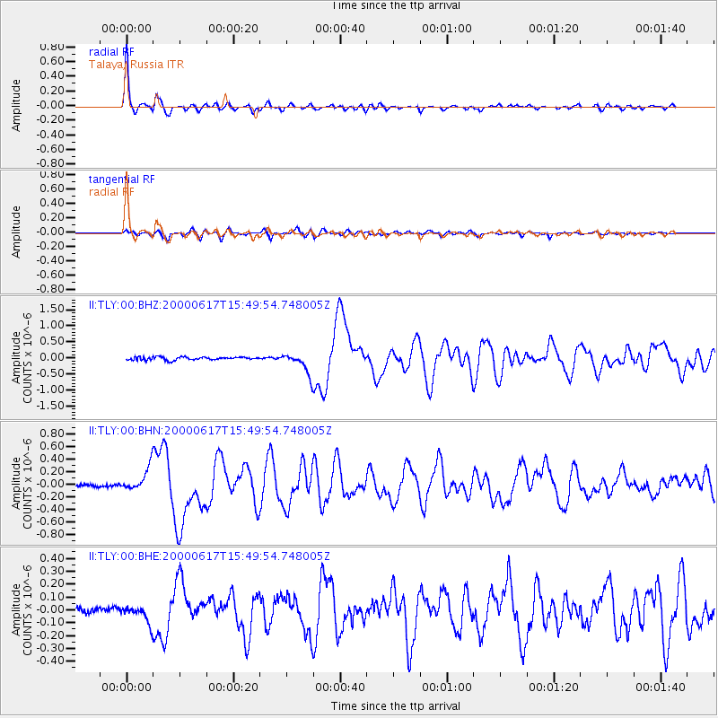
Signal To Noise
| Channel | StoN | STA | LTA |
| II:TLY:00:BHN:20000617T15:49:54.748005Z | 7.8039594 | 1.9076586E-7 | 2.4444754E-8 |
| II:TLY:00:BHE:20000617T15:49:54.748005Z | 2.2418516 | 6.686332E-8 | 2.9825046E-8 |
| II:TLY:00:BHZ:20000617T15:49:54.748005Z | 7.2465234 | 3.3356318E-7 | 4.6030785E-8 |
| Arrivals |
| Ps | 5.6 SECOND |
| PpPs | 15 SECOND |
| PsPs/PpSs | 20 SECOND |


