T25A Trinidad, CO, USA - Earthquake Result Viewer
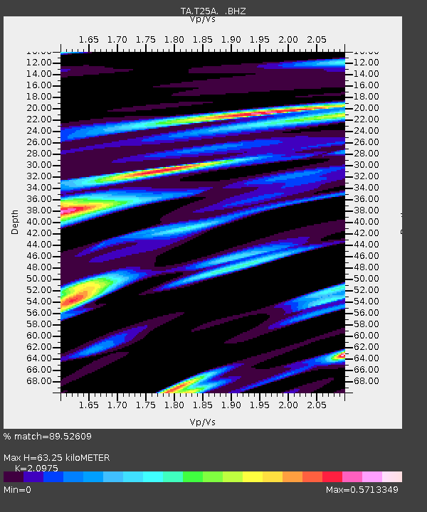
Earthquake location: Near East Coast Of Kamchatka
Earthquake latitude/longitude: 54.7/162.3
Earthquake time(UTC): 2013/11/12 (316) 07:03:51 GMT
Earthquake Depth: 43 km
Earthquake Magnitude: 6.4 MWW, 6.3 MWC, 6.4 MWW, 6.4 MWB, 6.5 MWC, 6.6 MI
Earthquake Catalog/Contributor: NEIC PDE/NEIC COMCAT
Network: TA USArray Transportable Network (new EarthScope stations)
Station: T25A Trinidad, CO, USA
Lat/Lon: 37.14 N/104.41 W
Elevation: 2017 m
Distance: 62.4 deg
Az: 64.16 deg
Baz: 319.16 deg
Ray Param: 0.060144868
Estimated Moho Depth: 63.25 km
Estimated Crust Vp/Vs: 2.10
Assumed Crust Vp: 6.316 km/s
Estimated Crust Vs: 3.011 km/s
Estimated Crust Poisson's Ratio: 0.35
Radial Match: 89.52609 %
Radial Bump: 400
Transverse Match: 80.774635 %
Transverse Bump: 400
SOD ConfigId: 626651
Insert Time: 2014-04-19 13:56:45.831 +0000
GWidth: 2.5
Max Bumps: 400
Tol: 0.001

Signal To Noise

ChannelStoNSTALTA
TA:T25A: :BHZ:20131112T07:13:38.999973Z11.4644572.4161757E-62.1075363E-7
TA:T25A: :BHN:20131112T07:13:38.999973Z4.84192379.443826E-71.9504284E-7
TA:T25A: :BHE:20131112T07:13:38.999973Z3.66535785.132293E-71.4002161E-7
Arrivals
Ps11 SECOND
PpPs30 SECOND
PsPs/PpSs41 SECOND