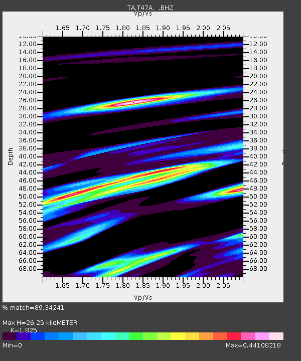
T47A Sharon Grove, KY, USA - Earthquake Result Viewer
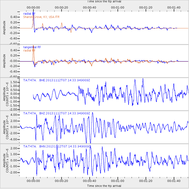
Earthquake location: Near East Coast Of Kamchatka
Earthquake latitude/longitude: 54.7/162.3
Earthquake time(UTC): 2013/11/12 (316) 07:03:51 GMT
Earthquake Depth: 43 km
Earthquake Magnitude: 6.4 MWW, 6.3 MWC, 6.4 MWW, 6.4 MWB, 6.5 MWC, 6.6 MI
Earthquake Catalog/Contributor: NEIC PDE/NEIC COMCAT
Network: TA USArray Transportable Network (new EarthScope stations)
Station: T47A Sharon Grove, KY, USA
Lat/Lon: 36.99 N/87.11 W
Elevation: 217 m
Distance: 71.1 deg
Az: 52.405 deg
Baz: 324.93 deg
Ray Param: 0.05448221
Estimated Moho Depth: 26.25 km
Estimated Crust Vp/Vs: 1.83
Assumed Crust Vp: 6.444 km/s
Estimated Crust Vs: 3.531 km/s
Estimated Crust Poisson's Ratio: 0.29
Radial Match: 89.34241 %
Radial Bump: 400
Transverse Match: 72.23283 %
Transverse Bump: 400
SOD ConfigId: 626651
Insert Time: 2014-04-19 13:56:48.171 +0000
GWidth: 2.5
Max Bumps: 400
Tol: 0.001

Signal To Noise

ChannelStoNSTALTA
TA:T47A: :BHZ:20131112T07:14:33.949009Z5.01526261.4175588E-62.8264895E-7
TA:T47A: :BHN:20131112T07:14:33.949009Z2.43374927.9527314E-73.2676874E-7
TA:T47A: :BHE:20131112T07:14:33.949009Z1.51410535.404498E-73.569433E-7
Arrivals
Ps3.5 SECOND
PpPs11 SECOND
PsPs/PpSs15 SECOND