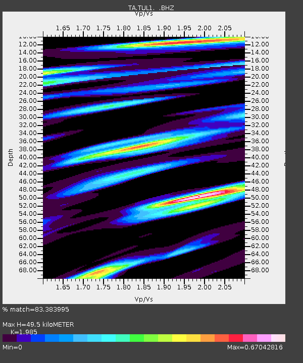
TUL1 Leonard, OK, USA - Earthquake Result Viewer

Earthquake location: Near East Coast Of Kamchatka
Earthquake latitude/longitude: 54.7/162.3
Earthquake time(UTC): 2013/11/12 (316) 07:03:51 GMT
Earthquake Depth: 43 km
Earthquake Magnitude: 6.4 MWW, 6.3 MWC, 6.4 MWW, 6.4 MWB, 6.5 MWC, 6.6 MI
Earthquake Catalog/Contributor: NEIC PDE/NEIC COMCAT
Network: TA USArray Transportable Network (new EarthScope stations)
Station: TUL1 Leonard, OK, USA
Lat/Lon: 35.91 N/95.79 W
Elevation: 256 m
Distance: 67.8 deg
Az: 59.1 deg
Baz: 322.14 deg
Ray Param: 0.056653816
Estimated Moho Depth: 49.5 km
Estimated Crust Vp/Vs: 1.99
Assumed Crust Vp: 6.498 km/s
Estimated Crust Vs: 3.273 km/s
Estimated Crust Poisson's Ratio: 0.33
Radial Match: 83.383995 %
Radial Bump: 366
Transverse Match: 74.56308 %
Transverse Bump: 400
SOD ConfigId: 626651
Insert Time: 2014-04-19 13:57:28.872 +0000
GWidth: 2.5
Max Bumps: 400
Tol: 0.001

Signal To Noise

ChannelStoNSTALTA
TA:TUL1: :BHZ:20131112T07:14:13.624973Z5.4816611.930765E-63.522226E-7
TA:TUL1: :BHN:20131112T07:14:13.624973Z3.70893749.901113E-72.669528E-7
TA:TUL1: :BHE:20131112T07:14:13.624973Z3.2422939.720575E-72.9980558E-7
Arrivals
Ps7.8 SECOND
PpPs22 SECOND
PsPs/PpSs30 SECOND