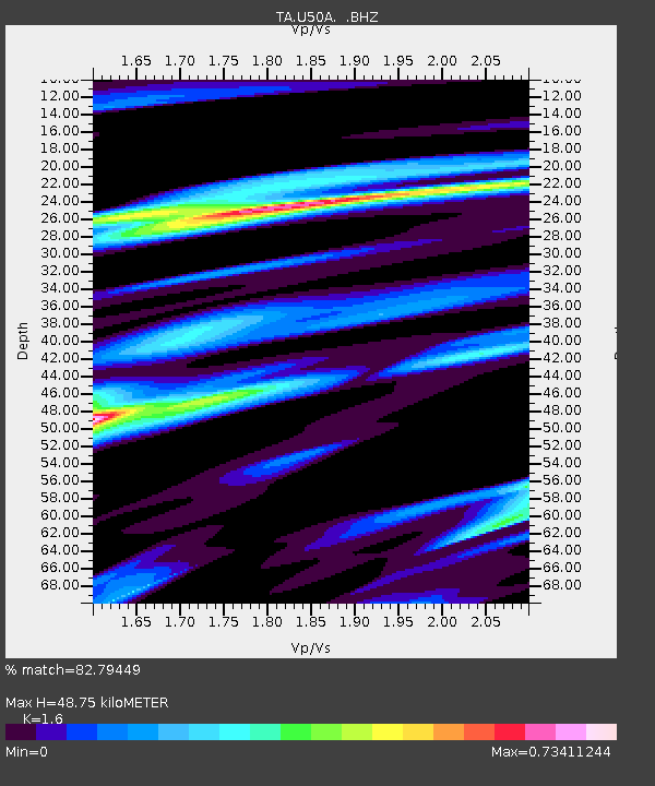
U50A Jamestown, TN, USA - Earthquake Result Viewer

Earthquake location: Near East Coast Of Kamchatka
Earthquake latitude/longitude: 54.7/162.3
Earthquake time(UTC): 2013/11/12 (316) 07:03:51 GMT
Earthquake Depth: 43 km
Earthquake Magnitude: 6.4 MWW, 6.3 MWC, 6.4 MWW, 6.4 MWB, 6.5 MWC, 6.6 MI
Earthquake Catalog/Contributor: NEIC PDE/NEIC COMCAT
Network: TA USArray Transportable Network (new EarthScope stations)
Station: U50A Jamestown, TN, USA
Lat/Lon: 36.42 N/84.84 W
Elevation: 474 m
Distance: 72.6 deg
Az: 51.171 deg
Baz: 325.891 deg
Ray Param: 0.05348896
Estimated Moho Depth: 48.75 km
Estimated Crust Vp/Vs: 1.60
Assumed Crust Vp: 6.476 km/s
Estimated Crust Vs: 4.047 km/s
Estimated Crust Poisson's Ratio: 0.18
Radial Match: 82.79449 %
Radial Bump: 400
Transverse Match: 70.607376 %
Transverse Bump: 400
SOD ConfigId: 626651
Insert Time: 2014-04-19 13:57:38.231 +0000
GWidth: 2.5
Max Bumps: 400
Tol: 0.001

Signal To Noise

ChannelStoNSTALTA
TA:U50A: :BHZ:20131112T07:14:42.925022Z4.5098991.0353141E-62.2956479E-7
TA:U50A: :BHN:20131112T07:14:42.925022Z3.2949544.210871E-71.2779756E-7
TA:U50A: :BHE:20131112T07:14:42.925022Z1.22348923.3857881E-72.7673215E-7
Arrivals
Ps4.7 SECOND
PpPs19 SECOND
PsPs/PpSs24 SECOND