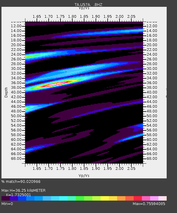
U57A Blanch, NC, USA - Earthquake Result Viewer

Earthquake location: Near East Coast Of Kamchatka
Earthquake latitude/longitude: 54.7/162.3
Earthquake time(UTC): 2013/11/12 (316) 07:03:51 GMT
Earthquake Depth: 43 km
Earthquake Magnitude: 6.4 MWW, 6.3 MWC, 6.4 MWW, 6.4 MWB, 6.5 MWC, 6.6 MI
Earthquake Catalog/Contributor: NEIC PDE/NEIC COMCAT
Network: TA USArray Transportable Network (new EarthScope stations)
Station: U57A Blanch, NC, USA
Lat/Lon: 36.43 N/79.34 W
Elevation: 178 m
Distance: 75.0 deg
Az: 47.284 deg
Baz: 328.062 deg
Ray Param: 0.051890623
Estimated Moho Depth: 36.25 km
Estimated Crust Vp/Vs: 1.73
Assumed Crust Vp: 6.419 km/s
Estimated Crust Vs: 3.705 km/s
Estimated Crust Poisson's Ratio: 0.25
Radial Match: 90.020966 %
Radial Bump: 292
Transverse Match: 68.10444 %
Transverse Bump: 400
SOD ConfigId: 626651
Insert Time: 2014-04-19 13:57:52.696 +0000
GWidth: 2.5
Max Bumps: 400
Tol: 0.001

Signal To Noise

ChannelStoNSTALTA
TA:U57A: :BHZ:20131112T07:14:56.999973Z4.45697981.2033895E-62.7000112E-7
TA:U57A: :BHN:20131112T07:14:56.999973Z3.10427215.302681E-71.7081881E-7
TA:U57A: :BHE:20131112T07:14:56.999973Z1.32771582.257807E-71.7005199E-7
Arrivals
Ps4.3 SECOND
PpPs15 SECOND
PsPs/PpSs19 SECOND